File:Jan Janssonius, Palestina, siue Terrae Sanctae descriptio (FL6880230 2368659).jpg
Jump to navigation
Jump to search

Size of this preview: 702 × 599 pixels. Other resolutions: 281 × 240 pixels | 562 × 480 pixels | 899 × 768 pixels | 1,199 × 1,024 pixels | 2,398 × 2,048 pixels | 2,800 × 2,391 pixels.
Original file (2,800 × 2,391 pixels, file size: 4.04 MB, MIME type: image/jpeg)
Captions
Captions
Add a one-line explanation of what this file represents
Summary
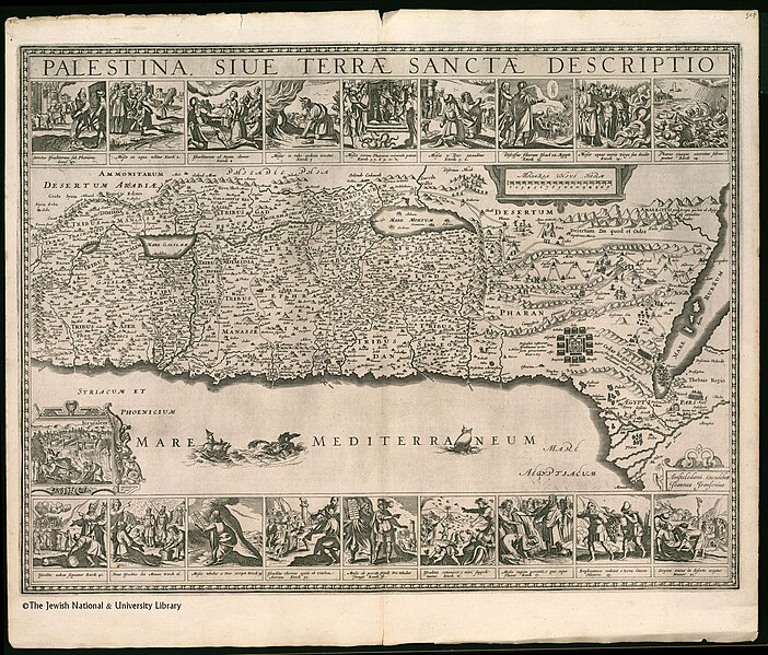
[edit]| Jan Janssonius: Palestina, siue Terrae Sanctae descriptio
( |
||||||||||||||||||||||||
|---|---|---|---|---|---|---|---|---|---|---|---|---|---|---|---|---|---|---|---|---|---|---|---|---|
| Artist |
| |||||||||||||||||||||||
| Contributors | Horn, Georg, 1620-1670 Hondius, Hendrik, 1597-1651 Adrichem, Christiaan van, 1533-1585 | |||||||||||||||||||||||
| Title |
Palestina, siue Terrae Sanctae descriptio |
|||||||||||||||||||||||
| Publisher |
Joannes Joansonius |
|||||||||||||||||||||||
| Description |
Palestina, siue Terrae Sanctae descriptio. |
|||||||||||||||||||||||
| Language | Latin | |||||||||||||||||||||||
| Publication date | 1658 | |||||||||||||||||||||||
| Dimensions | 436 × 567 mm (17.16 × 22.32 in) | |||||||||||||||||||||||
| Collection |
|
|||||||||||||||||||||||
| Current location |
|
|||||||||||||||||||||||
| Place of publication | Amsterdam | |||||||||||||||||||||||
| search Merhav catalog | Amsterdam | |||||||||||||||||||||||
| Notes | Copperplate; From: Jansson, Jan. Atlas major. Amsterdam, 1658. Vol. X. The map is a reprint of Hondius' Situs Terrae Promissionis, after Adrichom. First published in the Dutch edition of the author's Atlas novus, 1657-59, in vol. III.; Latin text on both sides of verso: Terra Sancta, sive Palaestina | |||||||||||||||||||||||
| IE PID | IE6880228 | |||||||||||||||||||||||
| Rosetta filename | FL6880230 | |||||||||||||||||||||||
| NNL item ID (P3959) | 990023686590205171 | |||||||||||||||||||||||
| search Merhav catalog | Latin, Jan Janssonius | |||||||||||||||||||||||
| search Merhav catalog | Twelve tribes of IsraelMapsJoannes Joansonius | |||||||||||||||||||||||
| Source/Photographer |
|
|||||||||||||||||||||||
| Other versions | ||||||||||||||||||||||||
| Jpg / Tif version |
|
|||||||||||||||||||||||

.jpg)

.jpg&action=edit§ion=1)
Licensing
[edit].jpg&action=edit§ion=2)
The copyright situation of this work is theoretically uncertain, because in the country of origin copyright lasts 70 years after the death of the author, and the date of the author's death is unknown. However, the date of creation of the work was over 120 years ago, and it is thus a reasonable assumption that the copyright has expired (see here for the community discussion). Do not use this template if the date of death of the author is known.
| |
| This file has been identified as being free of known restrictions under copyright law, including all related and neighboring rights. | |
File history
Click on a date/time to view the file as it appeared at that time.
| Date/Time | Thumbnail | Dimensions | User | Comment | |
|---|---|---|---|---|---|
| current | 16:36, 28 July 2023 | | 2,800 × 2,391 (4.04 MB) | Geagea (talk | contribs) | pattypan 22.03 |
You cannot overwrite this file.
File usage on Commons
The following page uses this file:
.jpg&oldid=789336265)