File:Jaciments de Messel.jpg
Jump to navigation
Jump to search

Size of this preview: 800 × 600 pixels. Other resolutions: 320 × 240 pixels | 640 × 480 pixels | 1,024 × 768 pixels.
Original file (1,024 × 768 pixels, file size: 807 KB, MIME type: image/jpeg)
Captions
Captions
Add a one-line explanation of what this file represents
Summary
[edit]
| Description |
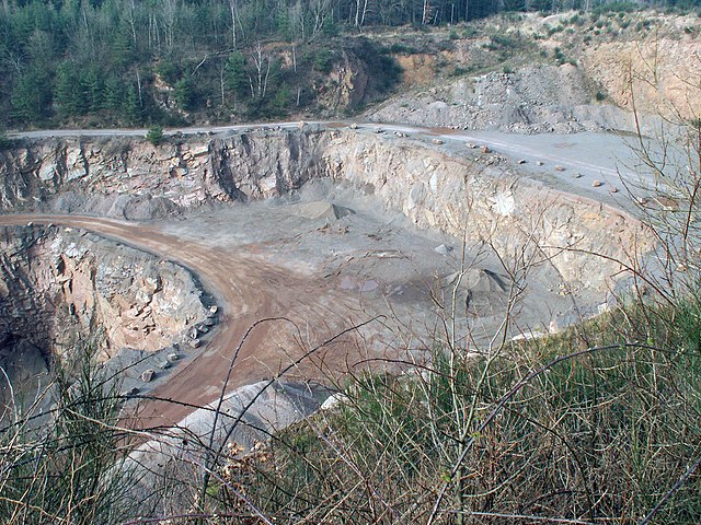
Deutsch: Syenitsteinbruch am Teufelsplatzweg zwischen Messel, Roßdorf und Dieburg, Südhessen. Der hier abgebaute Syenit gehört zum kristallinen Grundgebirge (Mitteldeutsche Kristallinschwelle der Varisziden), auf dem sich weiter nördlich die eozänen Sedimente der Grube Messel (Messel-Formation) ablagerten, und das einen nördlichen Ausläufer des Kristallinen Odenwalds darstellt.
English: Syenite quarry at Teufelsplatzweg (“devil's place route”) between the villages Messel, Rossdorf and Dieburg, southern Hesse, Germany. The syenite quarried here is part of the crystalline basement (Mid-German Crystalline Rise of the Variscides), on which further to the north the Eocene sediments of the Grube Messel (Messel Formation) came to rest and which is a northerly extension of the crystalline part of the Odenwald Mts. Syenitabbau |
| Date | Taken on 20 February 2007 |
| Source | Flickr |
| Author | froutes |
| Camera location | | View this and other nearby images on: OpenStreetMap |
|---|
Licensing
[edit]
This file is licensed under the Creative Commons Attribution-Share Alike 2.0 Generic license.
- You are free:
- to share – to copy, distribute and transmit the work
- to remix – to adapt the work
- Under the following conditions:
- attribution – You must give appropriate credit, provide a link to the license, and indicate if changes were made. You may do so in any reasonable manner, but not in any way that suggests the licensor endorses you or your use.
- share alike – If you remix, transform, or build upon the material, you must distribute your contributions under the same or compatible license as the original.
| This image, originally posted to Flickr, was reviewed on 17 January 2008 by the administrator or reviewer GeorgHH, who confirmed that it was available on Flickr under the stated license on that date. |
File history
Click on a date/time to view the file as it appeared at that time.
| Date/Time | Thumbnail | Dimensions | User | Comment | |
|---|---|---|---|---|---|
| current | 14:55, 17 January 2008 | | 1,024 × 768 (807 KB) | GeorgHH (talk | contribs) | full resolution from http://flickr.com/photos/froutes/1224329569/ |
| 21:36, 31 December 2007 |  | 500 × 375 (238 KB) | Leptictidium (talk | contribs) | {{Cc-by-sa-2.0}} Taken from [http://flickr.com/photos/froutes/1224329569/ Flickr]. You can check the license. |
You cannot overwrite this file.
File usage on Commons
There are no pages that use this file.
File usage on other wikis
The following other wikis use this file:
- Usage on ar.wikipedia.org
- Usage on de.wikipedia.org
- Usage on ru.wikipedia.org