File:JNN-1843-Map.jpg
Jump to navigation
Jump to search

Size of this preview: 495 × 600 pixels. Other resolutions: 198 × 240 pixels | 396 × 480 pixels | 634 × 768 pixels | 845 × 1,024 pixels | 1,690 × 2,048 pixels | 9,484 × 11,491 pixels.
Original file (9,484 × 11,491 pixels, file size: 11.96 MB, MIME type: image/jpeg)
Captions
Captions
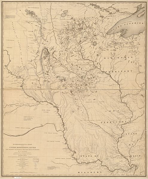
Upper Mississippi River, 1836-40. By J. N. Nicollet assisted by Lieut. J. C. Fremont, of the Bureau of the Corps of Topographical Engineers authorized by the War Department.
| Warning | The original file is very high-resolution. It might not load properly or could cause your browser to freeze when opened at full size. |
|---|
Summary
[edit]| Description |
English: Hydrographical basin of the upper Mississippi River from astronomical and barometrical observations, surveys, and information. By J. N. Nicollet, in the years 1836, 37, 38, 39, and 40; assisted in 1838, 39 & 40, by Lieut. J. C. Fremont, of the Corps of Topographical Engineers under the superintendence of the Bureau of the Corps of Topographical Engineers and authorized by the War Department. |
|||||||||||||||||||||||
| Date | ||||||||||||||||||||||||
| Source | U. S. Congress | |||||||||||||||||||||||
| Author |
|
|||||||||||||||||||||||

From Library of Congress map collection:http://lcweb2.loc.gov/ammem/gmdhtml/dsxphome.html
Licensing
[edit]
This work is in the public domain in the United States because it is a work prepared by an officer or employee of the United States Government as part of that person’s official duties under the terms of Title 17, Chapter 1, Section 105 of the US Code.
Note: This only applies to original works of the Federal Government and not to the work of any individual U.S. state, territory, commonwealth, county, municipality, or any other subdivision. This template also does not apply to postage stamp designs published by the United States Postal Service since 1978. (See § 313.6(C)(1) of Compendium of U.S. Copyright Office Practices). It also does not apply to certain US coins; see The US Mint Terms of Use.
|
 | |
| This file has been identified as being free of known restrictions under copyright law, including all related and neighboring rights. | ||
File history
Click on a date/time to view the file as it appeared at that time.
| Date/Time | Thumbnail | Dimensions | User | Comment | |
|---|---|---|---|---|---|
| current | 20:39, 12 February 2010 | | 9,484 × 11,491 (11.96 MB) | Gammagrass (talk | contribs) | {{Information |Description={{en|1=Hydrographical basin of the upper Mississippi River from astronomical and barometrical observations, surveys, and information. By J. N. Nicollet, in the years 1836, 37, 38, 39, and 40; assisted in 1838, 39 & 40, by Lieut. |
You cannot overwrite this file.
File usage on Commons
There are no pages that use this file.
File usage on other wikis
The following other wikis use this file:
- Usage on ca.wikipedia.org
- Usage on en.wikipedia.org
- Usage on es.wikipedia.org
- Usage on fr.wikipedia.org
Metadata
Categories:
- Joseph Nicollet
- Old maps of the Mississippi River
- 1843 maps of the United States
- Mississippi River in the 19th century
- Sioux maps
- History of indigenous peoples of the Great Plains
- Upper Mississippi River
- 1840s maps of Minnesota
- 1840s maps of Iowa
- 1840s maps of North Dakota
- 1840s maps of South Dakota
- 1840s maps of Wisconsin
- 1840s maps of Nebraska