File:JMA Surface Analysis Chart 08-10-2017 06Z.png

Original file (2,500 × 1,614 pixels, file size: 1.94 MB, MIME type: image/png)
Captions
Captions
Summary
[edit]| Description |
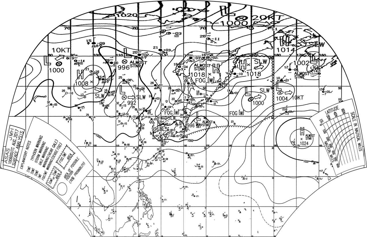
English: Surface analysis chart of Metarea XI for 10 August 2017, 06Z. Product of the Japan Meteorological Agency.
WWJP25 RJTD 100600 WARNING AND SUMMARY 100600. WARNING VALID 110600. WARNING IS UPDATED EVERY 6 HOURS. WARNING. DENSE FOG OBSERVED LOCALLY OVER SEA OF OKHOTSK NORTHERN PART OF SEA OF JAPAN. WARNING. DENSE FOG OBSERVED LOCALLY OVER WATERS BOUNDED BY 35N 140E 42N 143E 45N 150E 53N 160E 60N 164E 60N 180E 40N 180E 36N 170E 33N 140E 35N 140E. SUMMARY. LOW 996 HPA AT 36N 130E EAST SLOWLY. LOW 996 HPA AT 37N 146E ALMOST STATIONARY. LOW 1000 HPA AT 46N 170E ENE SLOWLY. HIGH 1018 HPA AT 54N 152E ALMOST STATIONARY. HIGH 1018 HPA AT 57N 169E ENE SLOWLY.
|
| Date | |
| Source | Japan Meteorological Agency weather chart page |
| Author | Based on "Surface Analysis Chart" (Japan Meteorological Agency) |
Licensing
[edit]This image was produced by the Japan Meteorological Agency. The legal notice (archive) stated that all the images published on their website is compatible with the Creative Commons Attribution 4.0 License, which means that all the images on this website is published under the Creative Commons Attribution 4.0 License unless otherwise specified.
This file is licensed under the Creative Commons Attribution 4.0 International license. Attribution: Japan Meteorological Agency
|
 |

| Annotations | This image is annotated: View the annotations at Commons |
File history
Click on a date/time to view the file as it appeared at that time.
| Date/Time | Thumbnail | Dimensions | User | Comment | |
|---|---|---|---|---|---|
| current | 14:57, 10 August 2017 | | 2,500 × 1,614 (1.94 MB) | Supportstorm (talk | contribs) | =={{int:filedesc}}== {{Information |description={{en|1=Surface analysis chart of Metarea XI for 10 August 2017, 06Z. Product of the Japan Meteorological Agency.}} WWJP25 RJTD 100600 WARNING AND SUMMARY 100600. WARNING VALID 110600. WARNING IS UPDATE... |
You cannot overwrite this file.
File usage on Commons
There are no pages that use this file.