File:JMA Surface Analysis Chart 08-07-2017 00Z.png

Original file (2,500 × 1,614 pixels, file size: 1.98 MB, MIME type: image/png)
Captions
Captions
Summary
[edit]| Description |
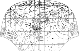
English: Surface analysis chart of Metarea XI for 7 August 2017, 00Z. Product of the Japan Meteorological Agency.
WWJP25 RJTD 070000 WARNING AND SUMMARY 070000. WARNING VALID 080000. WARNING IS UPDATED EVERY 6 HOURS. WARNING. DENSE FOG OBSERVED LOCALLY OVER SEA OF OKHOTSK SEA OF JAPAN YELLOW SEA. WARNING. DENSE FOG OBSERVED LOCALLY OVER WATERS BOUNDED BY 36N 141E 42N 141E 42N 143E 47N 152E 55N 162E 60N 163E 60N 180E 40N 180E 37N 163E 42N 160E 36N 143E 36N 141E. SUMMARY. LOW 996 HPA AT 46N 155E NW SLOWLY. LOW 1008 HPA AT 27N 156E ENE SLOWLY. LOW 1008 HPA AT 59N 167E ENE 10 KT. HIGH 1016 HPA AT 57N 147E ALMOST STATIONARY. REMARKS. SEVERE TROPICAL STORM 1705 NORU (1705) 970 HPA AT 33.1N 134.0E : SEE TROPICAL CYCLONE WARNING.
|
| Date | |
| Source | Japan Meteorological Agency weather chart page |
| Author | Based on "Surface Analysis Chart" (Japan Meteorological Agency) |
Licensing
[edit]This image was produced by the Japan Meteorological Agency. The legal notice (archive) stated that all the images published on their website is compatible with the Creative Commons Attribution 4.0 License, which means that all the images on this website is published under the Creative Commons Attribution 4.0 License unless otherwise specified.
This file is licensed under the Creative Commons Attribution 4.0 International license. Attribution: Japan Meteorological Agency
|
 |

| Annotations | This image is annotated: View the annotations at Commons |
File history
Click on a date/time to view the file as it appeared at that time.
| Date/Time | Thumbnail | Dimensions | User | Comment | |
|---|---|---|---|---|---|
| current | 05:24, 7 August 2017 | | 2,500 × 1,614 (1.98 MB) | Supportstorm (talk | contribs) | =={{int:filedesc}}== {{Information |description={{en|1=Surface analysis chart of Metarea XI for 7 August 2017, 00Z. Product of the Japan Meteorological Agency.}} WWJP25 RJTD 070000 WARNING AND SUMMARY 070000. WARNING VALID 080000. WARNING IS UPDATED... |
You cannot overwrite this file.
File usage on Commons
There are no pages that use this file.