File:JMA Surface Analysis Chart 01-08-2017 18Z.png

Original file (3,004 × 2,097 pixels, file size: 2.22 MB, MIME type: image/png)
Captions
Captions
Summary
[edit]| Description |
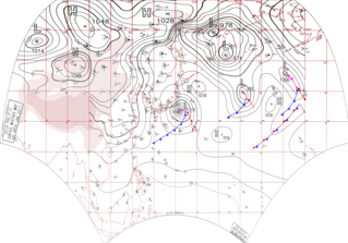
English: Surface analysis chart of Metarea XI for 8 January 2017, 18Z. Product of the Japan Meteorological Agency.
WWJP25 RJTD 081800 WARNING AND SUMMARY 081800. WARNING VALID 091800. WARNING IS UPDATED EVERY 6 HOURS. STORM WARNING. DEVELOPING LOW 976 HPA AT 34N 142E SEA EAST OF JAPAN MOVING EASTNORTHEAST 25 KNOTS. OCCLUDED FRONT FROM 34N 142E TO 34N 143E 33N 145E. WARM FRONT FROM 33N 145E TO 29N 147E 26N 149E. COLD FRONT FROM 33N 145E TO 27N 138E 23N 129E. EXPECTED WINDS 30 TO 65 KNOTS WITHIN 900 MILES OF LOW SOUTHEAST SEMICIRCLE AND 500 MILES ELSEWHERE FOR NEXT 24 HOURS. FORECAST POSITION FOR 090600UTC AT 36N 147E WITH UNCERTAINTY OF 50 MILES RADIUS. FORECAST POSITION FOR 091800UTC AT 39N 152E WITH UNCERTAINTY OF 85 MILES RADIUS. STORM WARNING. DEVELOPING LOW 992 HPA AT 40N 171E SEA SOUTH OF ALEUTIANS MOVING EASTNORTHEAST 30 KNOTS. OCCLUDED FRONT FROM 40N 171E TO 39N 172E 37N 172E. WARM FRONT FROM 37N 172E TO 35N 174E 33N 176E. COLD FRONT FROM 37N 172E TO 33N 168E 31N 161E. EXPECTED WINDS 30 TO 60 KNOTS WITHIN 600 MILES OF LOW SOUTH SEMICIRCLE AND 300 MILES ELSEWHERE FOR NEXT 12 HOURS. FORECAST POSITION FOR 090600UTC AT 42N 176E WITH UNCERTAINTY OF 50 MILES RADIUS. FORECAST POSITION FOR 091800UTC AT 42N 179E WITH UNCERTAINTY OF 85 MILES RADIUS. GALE WARNING. DEVELOPED LOW 974 HPA AT 52N 163E SEA EAST OF KURILS MOVING NORTHEAST 10 KNOTS. WINDS 30 TO 40 KNOTS WITHIN 700 MILES OF LOW NORTHEAST SEMICIRCLE AND 500 MILES ELSEWHERE. WARNING. TROPICAL DEPRESSION 1004 HPA AT 10.2N 125.1E PHILIPPINES MOVING WESTNORTHWEST 06 KNOTS. POSITION FAIR. MAX WINDS 30 KNOTS NEAR CENTER. WARNING. DENSE FOG OBSERVED LOCALLY OVER BOHAI NORTHERN PART OF SOUTH CHINA SEA. SUMMARY. LOW 980 HPA AT 59N 158E WEST SLOWLY. HIGH 1016 HPA AT 42N 149E SE 15 KT. HIGH 1016 HPA AT 27N 161E EAST 25 KT. STATIONARY FRONT FROM 21N 176E TO 23N 178E 24N 180E.
|
| Date | |
| Source | Japan Meteorological Agency weather chart page |
| Author | Based on "Surface Analysis Chart" (Japan Meteorological Agency) |
Licensing
[edit]This image was produced by the Japan Meteorological Agency. The legal notice (archive) stated that all the images published on their website is compatible with the Creative Commons Attribution 4.0 License, which means that all the images on this website is published under the Creative Commons Attribution 4.0 License unless otherwise specified.
This file is licensed under the Creative Commons Attribution 4.0 International license. Attribution: Japan Meteorological Agency
|
 |

File history
Click on a date/time to view the file as it appeared at that time.
| Date/Time | Thumbnail | Dimensions | User | Comment | |
|---|---|---|---|---|---|
| current | 07:37, 24 August 2017 | | 3,004 × 2,097 (2.22 MB) | Supportstorm (talk | contribs) | Reanalysis |
| 15:29, 10 August 2017 |  | 2,500 × 1,614 (2.23 MB) | Supportstorm (talk | contribs) | =={{int:filedesc}}== {{Information |description={{en|1=Surface analysis chart of Metarea XI for 8 January 2017, 18Z. Product of the Japan Meteorological Agency.}} WWJP25 RJTD 081800 WARNING AND SUMMARY 081800. WARNING VALID 091800. WARNING IS UPDATE... |
You cannot overwrite this file.
File usage on Commons
There are no pages that use this file.