File:JMA Surface Analysis Chart 01-08-2017 00Z.png

Original file (3,004 × 2,097 pixels, file size: 2.22 MB, MIME type: image/png)
Captions
Captions
Summary
[edit]| Description |
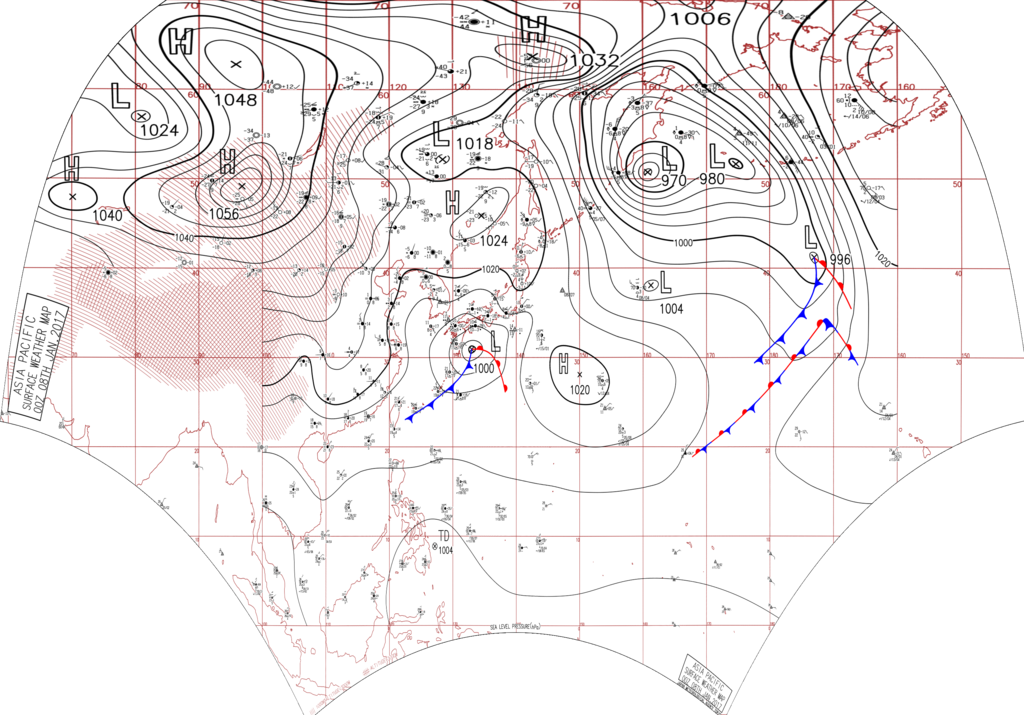
English: Surface analysis chart of Metarea XI for 8 January 2017, 00Z. Product of the Japan Meteorological Agency.
WWJP25 RJTD 080000 WARNING AND SUMMARY 080000. WARNING VALID 090000. WARNING IS UPDATED EVERY 6 HOURS. STORM WARNING. DEVELOPING LOW 970 HPA AT 51N 161E SEA EAST OF KURILS MOVING NORTHEAST SLOWLY. WINDS 30 TO 50 KNOTS WITHIN 1000 MILES OF LOW EAST SEMICIRCLE AND 700 MILES ELSEWHERE. FORECAST POSITION FOR 090000UTC AT 54N 163E WITH UNCERTAINTY OF 85 MILES RADIUS. ANOTHER LOW 980 HPA AT 52N 173E MOVING NORTHNORTHWEST 40 KNOTS. STORM WARNING. DEVELOPING LOW 1002 HPA AT 31N 133E SEA SOUTH OF JAPAN MOVING EASTNORTHEAST 20 KNOTS. WARM FRONT FROM 31N 133E TO 31N 135E 26N 138E. COLD FRONT FROM 31N 133E TO 29N 132E 26N 128E 23N 123E. EXPECTED WINDS 30 TO 55 KNOTS WITHIN 600 MILES OF LOW SOUTHEAST SEMICIRCLE AND 300 MILES ELSEWHERE FOR NEXT 24 HOURS. FORECAST POSITION FOR 081200UTC AT 33N 139E WITH UNCERTAINTY OF 50 MILES RADIUS. FORECAST POSITION FOR 090000UTC AT 35N 144E WITH UNCERTAINTY OF 85 MILES RADIUS. STORM WARNING. DEVELOPING LOW 1008 HPA AT 37N 155E FAR OFF EAST OF JAPAN MOVING EAST 10 KNOTS. EXPECTED WINDS 30 TO 50 KNOTS WITHIN 600 MILES OF LOW SOUTH SEMICIRCLE AND 300 MILES ELSEWHERE FOR NEXT 24 HOURS. FORECAST POSITION FOR 090000UTC AT 42N 173E WITH UNCERTAINTY OF 85 MILES RADIUS. WARNING. TROPICAL DEPRESSION 1004 HPA AT 09.0N 127.1E SEA EAST OF MINDANAO MOVING NORTHWEST 09 KNOTS. POSITION FAIR. MAX WINDS 30 KNOTS NEAR CENTER. WARNING. DENSE FOG OBSERVED LOCALLY OVER YELLOW SEA EAST CHINA SEA NORTHERN PART OF SOUTH CHINA SEA. WARNING. DENSE FOG OBSERVED LOCALLY OVER WATERS BOUNDED BY 53N 160E 60N 164E 60N 180E 46N 180E 53N 160E. SUMMARY. HIGH 1024 HPA AT 46N 135E ESE 10 KT. HIGH 1020 HPA AT 28N 150E ESE 15 KT. OCCLUDED FRONT FROM 52N 173E TO 49N 180E 46N 175W. WARM FRONT FROM 46N 175W TO 43N 171W 39N 167W. COLD FRONT FROM 46N 175W TO 40N 174W 35N 176W 32N 180E 31N 179E. STATIONARY FRONT FROM 20N 173E TO 23N 176E 26N 180E.
|
| Date | |
| Source | Japan Meteorological Agency weather chart page |
| Author | Based on "Surface Analysis Chart" (Japan Meteorological Agency) |
Licensing
[edit]This image was produced by the Japan Meteorological Agency. The legal notice (archive) stated that all the images published on their website is compatible with the Creative Commons Attribution 4.0 License, which means that all the images on this website is published under the Creative Commons Attribution 4.0 License unless otherwise specified.
This file is licensed under the Creative Commons Attribution 4.0 International license. Attribution: Japan Meteorological Agency
|
 |

File history
Click on a date/time to view the file as it appeared at that time.
| Date/Time | Thumbnail | Dimensions | User | Comment | |
|---|---|---|---|---|---|
| current | 07:35, 24 August 2017 | | 3,004 × 2,097 (2.22 MB) | Supportstorm (talk | contribs) | Reanalysis |
| 15:24, 10 August 2017 |  | 2,500 × 1,614 (2.24 MB) | Supportstorm (talk | contribs) | =={{int:filedesc}}== {{Information |description={{en|1=Surface analysis chart of Metarea XI for 8 January 2017, 00Z. Product of the Japan Meteorological Agency.}} WWJP25 RJTD 080000 WARNING AND SUMMARY 080000. WARNING VALID 090000. WARNING IS UPDATE... |
You cannot overwrite this file.
File usage on Commons
There are no pages that use this file.