File:JMA Surface Analysis Chart 01-06-2017 12Z.png
Original file (3,004 × 2,097 pixels, file size: 2.15 MB, MIME type: image/png)
Captions
Captions
Summary
[edit]| Description |
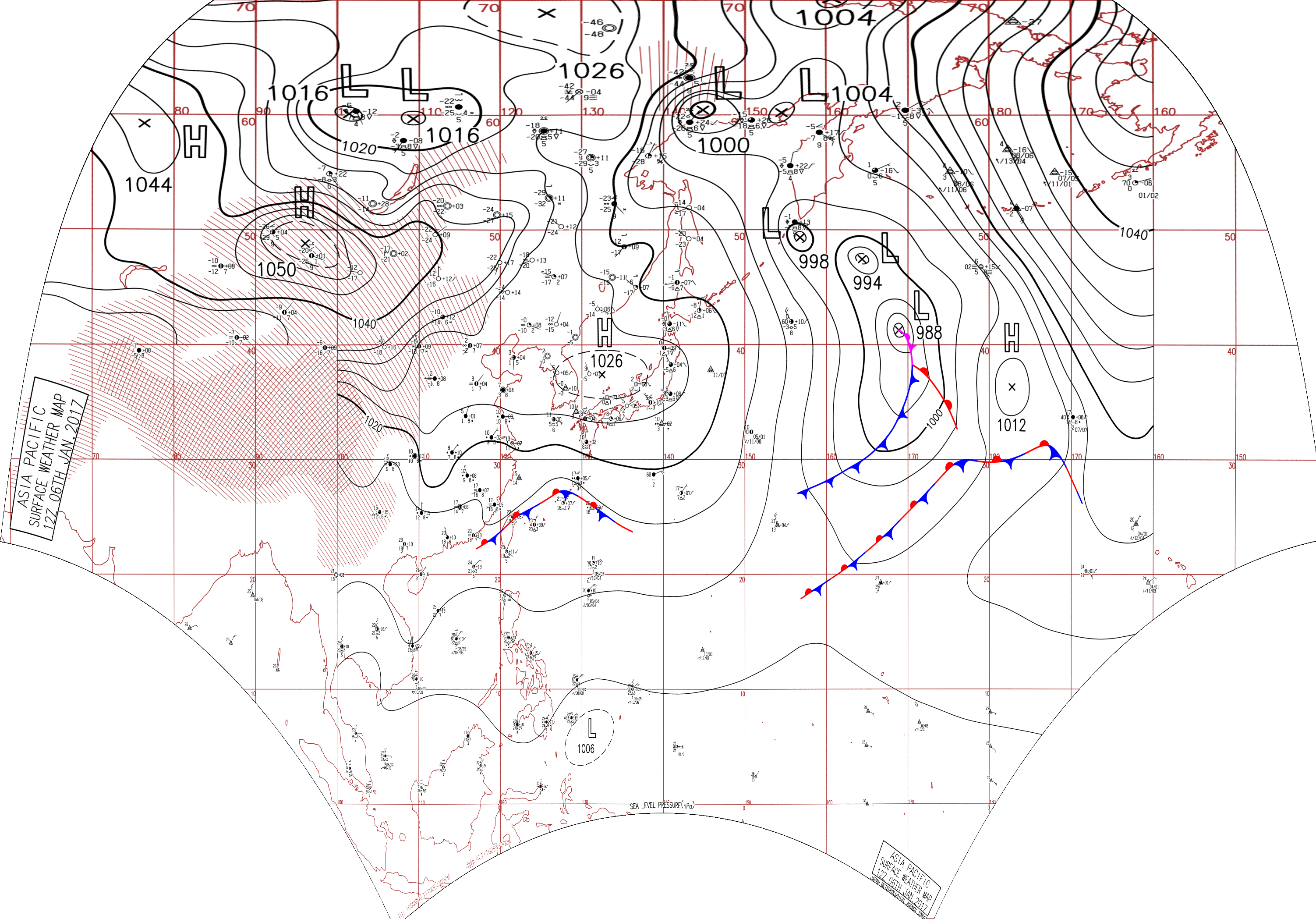
English: Surface analysis chart of Metarea XI for 6 January 2017, 12Z. Product of the Japan Meteorological Agency.
WWJP25 RJTD 061200 WARNING AND SUMMARY 061200. WARNING VALID 071200. WARNING IS UPDATED EVERY 6 HOURS. GALE WARNING. DEVELOPING LOW 988 HPA AT 41N 169E FAR OFF EAST OF JAPAN MOVING NORTH 25 KNOTS. OCCLUDED FRONT FROM 41N 169E TO 40N 170E 39N 170E. WARM FRONT FROM 39N 170E TO 36N 173E 33N 174E. COLD FRONT FROM 39N 170E TO 35N 168E 30N 164E 27N 158E. WINDS 30 TO 40 KNOTS WITHIN 1400 MILES OF LOW EAST SEMICIRCLE AND 700 MILES ELSEWHERE. GALE WARNING. DEVELOPED LOW 998 HPA AT 49N 157E SEA EAST OF KURILS MOVING SOUTH 15 KNOTS. WINDS 30 TO 35 KNOTS WITHIN 300 MILES OF LOW NORTHWEST SEMICIRCLE AND 200 MILES ELSEWHERE. WARNING. DENSE FOG OBSERVED LOCALLY OVER BOHAI YELLOW SEA EAST CHINA SEA NORTHERN PART OF SOUTH CHINA SEA. WARNING. DENSE FOG OBSERVED LOCALLY OVER WATERS BOUNDED BY 48N 160E 53N 160E 60N 163E 60N 180E 33N 180E 32N 173E 48N 160E. SUMMARY. LOW 994 HPA AT 47N 164E WNW 10 KT. LOW PRESSURE AREA 1006 HPA NEAR 05N 132E WEST SLOWLY. HIGH 1026 HPA AT 37N 135E EAST 15 KT. STATIONARY FRONT FROM 23N 117E TO 25N 122E 28N 127E 24N 134E. STATIONARY FRONT FROM 18N 162E TO 22N 168E 29N 173E 29N 177W.
|
| Date | |
| Source | Japan Meteorological Agency weather chart page |
| Author | Based on "Surface Analysis Chart" (Japan Meteorological Agency) |
Licensing
[edit]This image was produced by the Japan Meteorological Agency. The legal notice (archive) stated that all the images published on their website is compatible with the Creative Commons Attribution 4.0 License, which means that all the images on this website is published under the Creative Commons Attribution 4.0 License unless otherwise specified.
This file is licensed under the Creative Commons Attribution 4.0 International license. Attribution: Japan Meteorological Agency
|
 |

File history
Click on a date/time to view the file as it appeared at that time.
| Date/Time | Thumbnail | Dimensions | User | Comment | |
|---|---|---|---|---|---|
| current | 07:31, 24 August 2017 | | 3,004 × 2,097 (2.15 MB) | Supportstorm (talk | contribs) | Reanalysis |
| 05:28, 9 August 2017 |  | 2,500 × 1,614 (2.12 MB) | Supportstorm (talk | contribs) | =={{int:filedesc}}== {{Information |description={{en|1=Surface analysis chart of Metarea XI for 6 January 2017, 12Z. Product of the Japan Meteorological Agency.}} WWJP25 RJTD 061200 WARNING AND SUMMARY 061200. WARNING VALID 071200. WARNING IS UPDATE... |
You cannot overwrite this file.
File usage on Commons
There are no pages that use this file.