File:JMA Surface Analysis Chart 01-06-2017 00Z.png
Original file (3,004 × 2,097 pixels, file size: 2.17 MB, MIME type: image/png)
Captions
Captions
Summary
[edit]| Description |
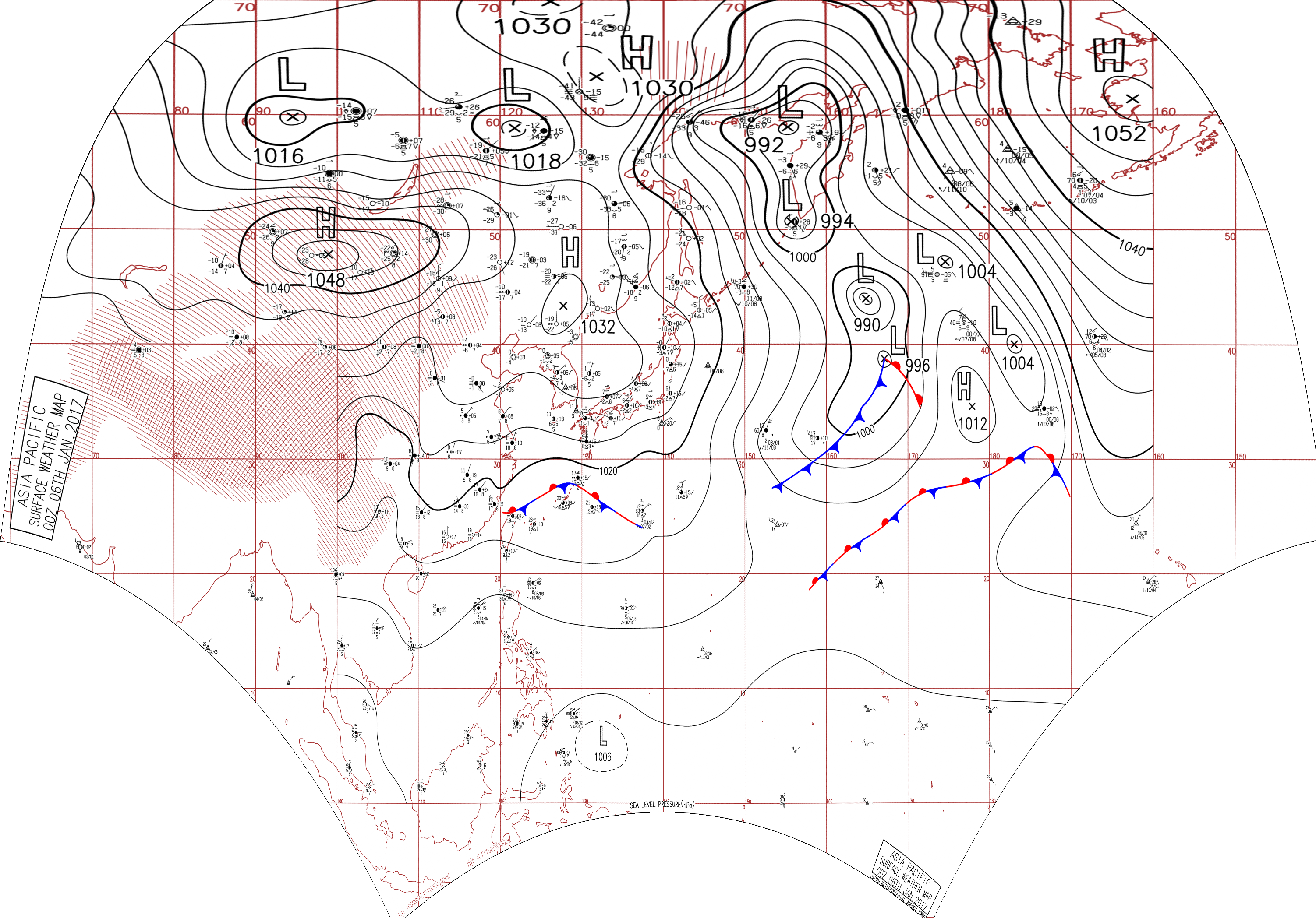
English: Surface analysis chart of Metarea XI for 6 January 2017, 00Z. Product of the Japan Meteorological Agency.
WWJP25 RJTD 060000 WARNING AND SUMMARY 060000. WARNING VALID 070000. WARNING IS UPDATED EVERY 6 HOURS. GALE WARNING. DEVELOPED LOW 988 HPA AT 44N 165E FAR OFF EAST OF JAPAN MOVING NORTH 30 KNOTS. WINDS 30 TO 45 KNOTS WITHIN 400 MILES OF LOW SOUTHEAST SEMICIRCLE AND 200 MILES ELSEWHERE. GALE WARNING. DEVELOPED LOW 994 HPA AT 51N 156E SEA AROUND KURILS ALMOST STATIONARY. WINDS 30 TO 35 KNOTS WITHIN 300 MILES OF LOW. GALE WARNING. DEVELOPING LOW 996 HPA AT 35N 164E FAR OFF EAST OF JAPAN MOVING EASTNORTHEAST 25 KNOTS. WINDS 30 TO 35 KNOTS WITHIN 900 MILES OF LOW WEST SEMICIRCLE AND 300 MILES ELSEWHERE. GALE WARNING. SOUTHEASTERLY WINDS 30 TO 35 KNOTS PREVAILING OVER WATERS BOUNDED BY 55N 170E 60N 170E 60N 180E 45N 180E 55N 170E. WARNING. DENSE FOG OBSERVED LOCALLY OVER YELLOW SEA EAST CHINA SEA NORTHERN PART OF SOUTH CHINA SEA. WARNING. DENSE FOG OBSERVED LOCALLY OVER WATERS BOUNDED BY 60N 163E 60N 176E 52N 176E 51N 180E 42N 180E 40N 175E 45N 168E 52N 163E 60N 163E. SUMMARY. LOW 992 HPA AT 59N 155E NNW 10 KT. LOW 1004 HPA AT 47N 175E NNW 15 KT. LOW PRESSURE AREA 1006 HPA NEAR 06N 131E WEST SLOWLY. HIGH 1032 HPA AT 43N 128E SE 15 KT. HIGH 1012 HPA AT 34N 178E ENE 15 KT. STATIONARY FRONT FROM 25N 111E TO 28N 117E 28N 122E 28N 125E 27N 128E. STATIONARY FRONT FROM 21N 160E TO 23N 166E 26N 170E 28N 176E 29N 180E.
|
| Date | |
| Source | Japan Meteorological Agency weather chart page |
| Author | Based on "Surface Analysis Chart" (Japan Meteorological Agency) |
Licensing
[edit]This image was produced by the Japan Meteorological Agency. The legal notice (archive) stated that all the images published on their website is compatible with the Creative Commons Attribution 4.0 License, which means that all the images on this website is published under the Creative Commons Attribution 4.0 License unless otherwise specified.
This file is licensed under the Creative Commons Attribution 4.0 International license. Attribution: Japan Meteorological Agency
|
 |

File history
Click on a date/time to view the file as it appeared at that time.
| Date/Time | Thumbnail | Dimensions | User | Comment | |
|---|---|---|---|---|---|
| current | 07:31, 24 August 2017 | | 3,004 × 2,097 (2.17 MB) | Supportstorm (talk | contribs) | Reanalysis |
| 05:27, 9 August 2017 |  | 2,500 × 1,614 (2.12 MB) | Supportstorm (talk | contribs) | =={{int:filedesc}}== {{Information |description={{en|1=Surface analysis chart of Metarea XI for 6 January 2017, 00Z. Product of the Japan Meteorological Agency.}} WWJP25 RJTD 060000 WARNING AND SUMMARY 060000. WARNING VALID 070000. WARNING IS UPDATE... |
You cannot overwrite this file.
File usage on Commons
There are no pages that use this file.