File:JMA Surface Analysis Chart 01-01-2017 12Z.png
Original file (3,004 × 2,097 pixels, file size: 2.21 MB, MIME type: image/png)
Captions
Captions
Summary
[edit]| Description |
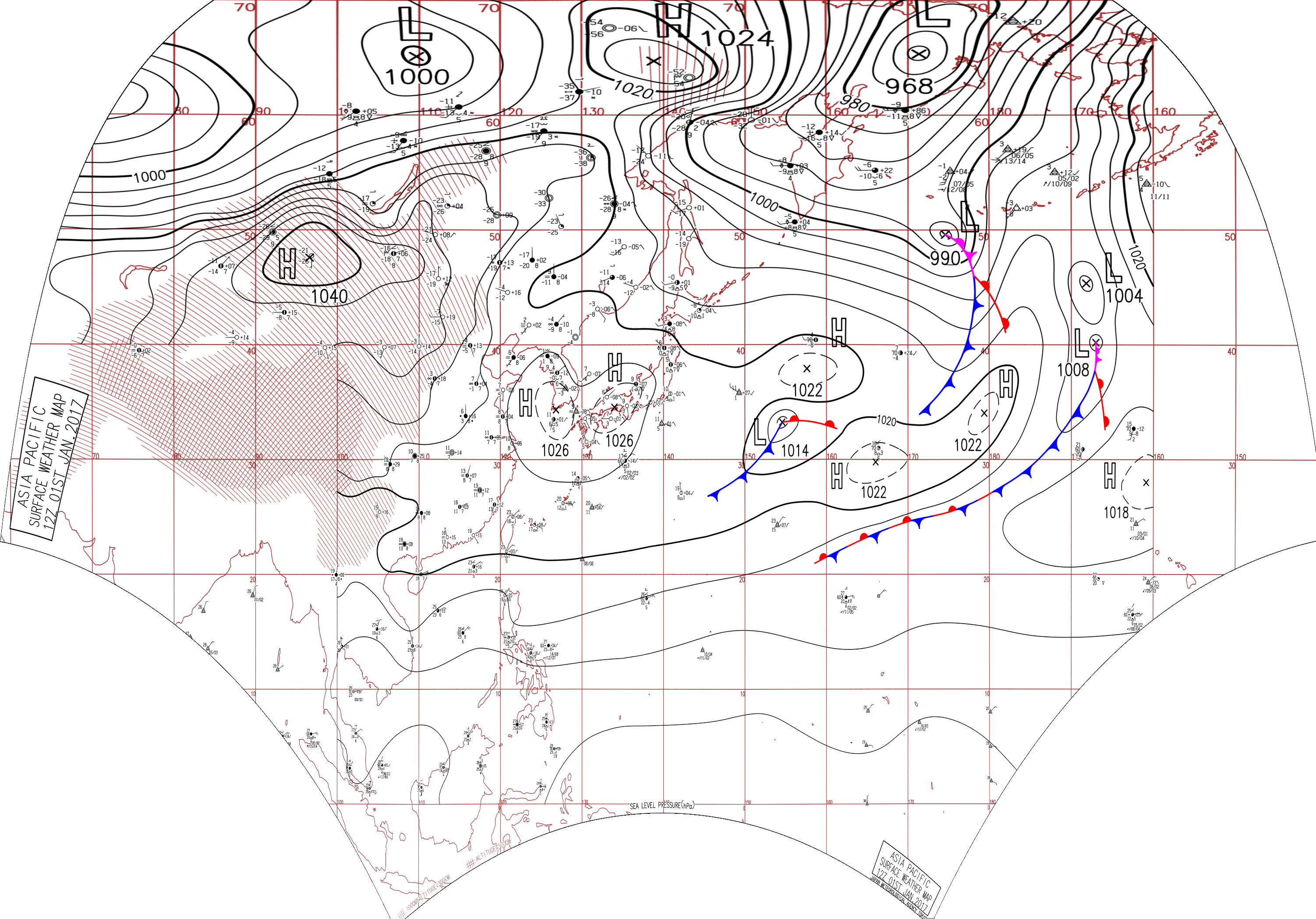
English: Surface analysis chart of Metarea XI for 1 January 2017, 12Z. Product of the Japan Meteorological Agency.
WWJP25 RJTD 011200 WARNING AND SUMMARY 011200. WARNING VALID 021200. WARNING IS UPDATED EVERY 6 HOURS. GALE WARNING. DEVELOPED LOW 990 HPA AT 50N 175E SEA AROUND ALEUTIANS MOVING NORTHNORTHEAST 20 KNOTS. OCCLUDED FRONT FROM 50N 174E TO 50N 177E 48N 178E 46N 178E. WARM FRONT FROM 46N 178E TO 44N 179W 42N 178W. COLD FRONT FROM 46N 178E TO 40N 177E 35N 174E. WINDS 30 TO 40 KNOTS WITHIN 600 MILES OF LOW SOUTH SEMICIRCLE AND 300 MILES ELSEWHERE. GALE WARNING. SOUTHWESTERLY WINDS 30 TO 40 KNOTS PREVAILING OVER WATERS BOUNDED BY 58N 170E 60N 169E 60N 180E 58N 180E 56N 176E 58N 170E. GALE WARNING. DEVELOPING LOW 1016 HPA AT 33N 155E FAR OFF EAST OF JAPAN MOVING EAST 30 KNOTS. WARM FRONT FROM 33N 155E TO 33N 158E 33N 161E. COLD FRONT FROM 33N 155E TO 30N 152E 28N 147E. EXPECTED WINDS 30 TO 35 KNOTS WITHIN 300 MILES OF LOW FOR NEXT 24 HOURS. WARNING. DENSE FOG OBSERVED LOCALLY OVER BOHAI YELLOW SEA EAST CHINA SEA. SUMMARY. HIGH 1026 HPA AT 34N 133E EAST 25 KT. HIGH 1022 HPA AT 38N 157E EAST 20 KT. HIGH 1022 HPA AT 30N 166E EAST 25 KT. HIGH 1020 HPA AT 35N 180E EAST 20 KT. STATIONARY FRONT FROM 27N 180E TO 24N 171E 21N 160E.
|
| Date | |
| Source | Japan Meteorological Agency weather chart page |
| Author | Based on "Surface Analysis Chart" (Japan Meteorological Agency) |
Licensing
[edit]This image was produced by the Japan Meteorological Agency. The legal notice (archive) stated that all the images published on their website is compatible with the Creative Commons Attribution 4.0 License, which means that all the images on this website is published under the Creative Commons Attribution 4.0 License unless otherwise specified.
This file is licensed under the Creative Commons Attribution 4.0 International license. Attribution: Japan Meteorological Agency
|
 |

| Annotations | This image is annotated: View the annotations at Commons |
File history
Click on a date/time to view the file as it appeared at that time.
| Date/Time | Thumbnail | Dimensions | User | Comment | |
|---|---|---|---|---|---|
| current | 07:18, 24 August 2017 | | 3,004 × 2,097 (2.21 MB) | Supportstorm (talk | contribs) | Reanalysis |
| 05:09, 9 August 2017 |  | 2,500 × 1,614 (2.11 MB) | Supportstorm (talk | contribs) | =={{int:filedesc}}== {{Information |description={{en|1=Surface analysis chart of Metarea XI for 1 January 2017, 12Z. Product of the Japan Meteorological Agency.}} WWJP25 RJTD 011200 WARNING AND SUMMARY 011200. WARNING VALID 021200. WARNING IS UPDATE... |
You cannot overwrite this file.
File usage on Commons
There are no pages that use this file.