File:JAPAN EARTHQUAKE 20110311-de.png
Jump to navigation
Jump to search

Size of this preview: 671 × 600 pixels. Other resolutions: 269 × 240 pixels | 537 × 480 pixels | 874 × 781 pixels.
Original file (874 × 781 pixels, file size: 170 KB, MIME type: image/png)
Captions
Captions
Add a one-line explanation of what this file represents
| Description |
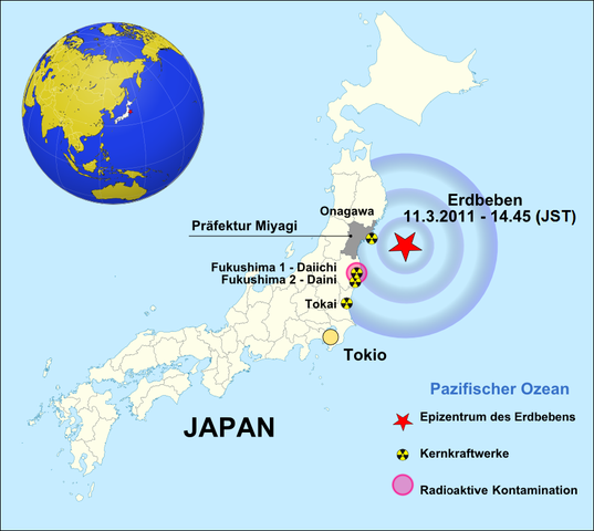
Deutsch: Japan Erdbeben 11.3.2011
English: EARTHQUAKE / 11.3.2011 - 14:45 (PT) / 8,9 MAGNITUDE |
| Date | (UTC) |
| Source |
|
| Author |
uploader on de.wikipedia.org: Brücke-Osteuropa at de.wikipedia
|
| Other versions | • česká verze • english version • rumantsch version • español version |
.svg)
| This is a retouched picture, which means that it has been digitally altered from its original version. Modifications: translated into German. The original can be viewed here: JAPAN EARTHQUAKE 20110311.png:
|
This file is licensed under the Creative Commons Attribution-Share Alike 3.0 Unported license.
- You are free:
- to share – to copy, distribute and transmit the work
- to remix – to adapt the work
- Under the following conditions:
- attribution – You must give appropriate credit, provide a link to the license, and indicate if changes were made. You may do so in any reasonable manner, but not in any way that suggests the licensor endorses you or your use.
- share alike – If you remix, transform, or build upon the material, you must distribute your contributions under the same or compatible license as the original.

|
Permission is granted to copy, distribute and/or modify this document under the terms of the GNU Free Documentation License, Version 1.2 or any later version published by the Free Software Foundation; with no Invariant Sections, no Front-Cover Texts, and no Back-Cover Texts. A copy of the license is included in the section entitled GNU Free Documentation License. |
Original upload log
[edit]
This image is a derivative work of the following images:
- File:Japan_location_map_with_side_map_of_the_Ryukyu_Islands.svg licensed with Cc-by-sa-3.0, GFDL
- 2010-10-30T13:53:18Z NordNordWest 413x373 (948276 Bytes) Liancourts Rock boundary
- 2010-09-17T01:15:53Z Dinamik 413x373 (1638123 Bytes) medium color for disputed territories
- 2010-03-21T11:41:34Z Chumwa 413x373 (1597074 Bytes) Präfekturgrenzen bereinigt
- 2010-03-20T13:33:30Z Chumwa 413x373 (1793386 Bytes) Trennlinie zu Nebenkarte etwas verbreitert
- 2010-03-20T09:50:05Z Chumwa 413x373 (2010954 Bytes) == {{int:filedesc}} == {{Information |Description= {{de|Postionskarte von [[:de:Japan|Japan]]}} Quadratische Plattkarte. Bei Nutzung der Hauptkarte mit den Hauptinseln gelten folgende geographische Begrenzungen für die (Ges
- File:JAPAN_EARTHQUAKE_20110311.png licensed with Cc-by-sa-3.0, GFDL
- 2011-03-15T15:23:06Z Lordmetroid 874x781 (163929 Bytes) Fixed spelling mistake
- 2011-03-15T13:36:30Z W.Rebel 874x781 (167624 Bytes) Update
- 2011-03-13T16:30:04Z W.Rebel 874x781 (113606 Bytes) Update
- 2011-03-13T10:37:51Z W.Rebel 874x781 (109235 Bytes) {{Information |Description=EARTHQUAKE / 11.3.2011 - 14:45 (PT) / 8,9 MAGNITUDE |Source=*[[:File:Japan_location_map_with_side_map_of_the_Ryukyu_Islands.svg|]] |Date=2011-03-13 10:36 (UTC) |Author=*[[:File:Japan_location_map_wi
Uploaded with derivativeFX
Original upload log (transfer from de.wp to commons)
[edit]
The original description page was here. All following user names refer to de.wikipedia.
- 2011-03-15 07:58 Brücke-Osteuropa 874×781× (121731 bytes) {{Information |Beschreibung = Japan Erdbeben 11.3.2011 |Quelle = Japan_location_map_with_side_map_of_the_Ryukyu_Islands.svg: Maximilian Dörrbecker (Chumwa) |Urheber = Brücke-Osteuropa |Datum = 15.03.2011 |Genehmigung = Derivat von JAPAN EARTHQUAKE 20110311.png |Andere Versionen = JAPAN EARTHQUAKE 20110311.png |Anmerkungen = Überführung ins Deutsche }}
File history
Click on a date/time to view the file as it appeared at that time.
| Date/Time | Thumbnail | Dimensions | User | Comment | |
|---|---|---|---|---|---|
| current | 19:00, 7 October 2011 | | 874 × 781 (170 KB) | NordNordWest (talk | contribs) | correct German (again!) |
| 00:55, 3 April 2011 |  | 874 × 781 (254 KB) | Obankston (talk | contribs) | corrected timezone | |
| 12:37, 19 March 2011 |  | 874 × 781 (226 KB) | W.Rebel (talk | contribs) | update globe | |
| 10:02, 19 March 2011 |  | 874 × 781 (157 KB) | Mps2 (talk | contribs) | ||
| 12:09, 16 March 2011 |  | 874 × 781 (200 KB) | Dr. Bernd Gross (talk | contribs) | ||
| 12:06, 16 March 2011 |  | 874 × 781 (200 KB) | Dr. Bernd Gross (talk | contribs) | ||
| 15:42, 15 March 2011 |  | 874 × 781 (119 KB) | Quedel (talk | contribs) | {{Information |Description={{de|Postionskarte von Japan Quadratische Plattkarte. Bei Nutzung der Hauptkarte mit den Hauptinseln gelten folgende geographische Begrenzungen für die (Gesamt-)Karte: * N: 45°51'37" N (45.86°N) * S: 30°01'13" |
You cannot overwrite this file.
File usage on Commons
There are no pages that use this file.
File usage on other wikis
The following other wikis use this file:
- Usage on als.wikipedia.org
- Usage on de.wikipedia.org
- Usage on lb.wikipedia.org