File:Jærstrender satellitt.jpg
Jump to navigation
Jump to search

Size of this preview: 296 × 599 pixels. Other resolutions: 118 × 240 pixels | 237 × 480 pixels | 784 × 1,587 pixels.
Original file (784 × 1,587 pixels, file size: 206 KB, MIME type: image/jpeg)
Captions
Captions
Add a one-line explanation of what this file represents
| Description |
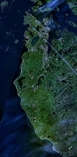
English: Satellite imagery of the beaches on Jæren in Rogaland, on the southwestern coast of Norway.
Norsk nynorsk: Satellittbilete av i Rogaland. |
| Source | Taken from NASA WorldWind, cropped and stitched by the uploader. |
| Author | NASA Landsat imagery |
| This image is in the public domain because it is a screenshot from NASA’s globe software World Wind using a public domain layer, such as Blue Marble, MODIS, Landsat, SRTM, USGS or GLOBE.
|
 |
File history
Click on a date/time to view the file as it appeared at that time.
| Date/Time | Thumbnail | Dimensions | User | Comment | |
|---|---|---|---|---|---|
| current | 23:03, 27 March 2008 | | 784 × 1,587 (206 KB) | Ranveig (talk | contribs) | {{Information |Description= {{en|Satellite imagery of the beaches on Jæren in Rogaland, on the southwestern coast of Norway.}} {{nn|Satellittbilete av nn:Jærstrendene i Rogaland.}} |Source= |Date= |Author=NASA Landsat imagery, taken from NAS |
You cannot overwrite this file.
File usage on Commons
There are no pages that use this file.
File usage on other wikis
The following other wikis use this file:
- Usage on nn.wikipedia.org
- Usage on no.wikipedia.org
- Usage on sv.wikipedia.org