File:Iwo Jima, Anchorage Chart, 1944 (cropped).jpg
Jump to navigation
Jump to search
Size of this preview: 449 × 599 pixels. Other resolutions: 180 × 240 pixels | 360 × 480 pixels | 576 × 768 pixels | 768 × 1,024 pixels | 1,535 × 2,048 pixels | 3,009 × 4,013 pixels.
Original file (3,009 × 4,013 pixels, file size: 1.08 MB, MIME type: image/jpeg)
Captions
Captions
Add a one-line explanation of what this file represents
Summary
[edit]| Description |
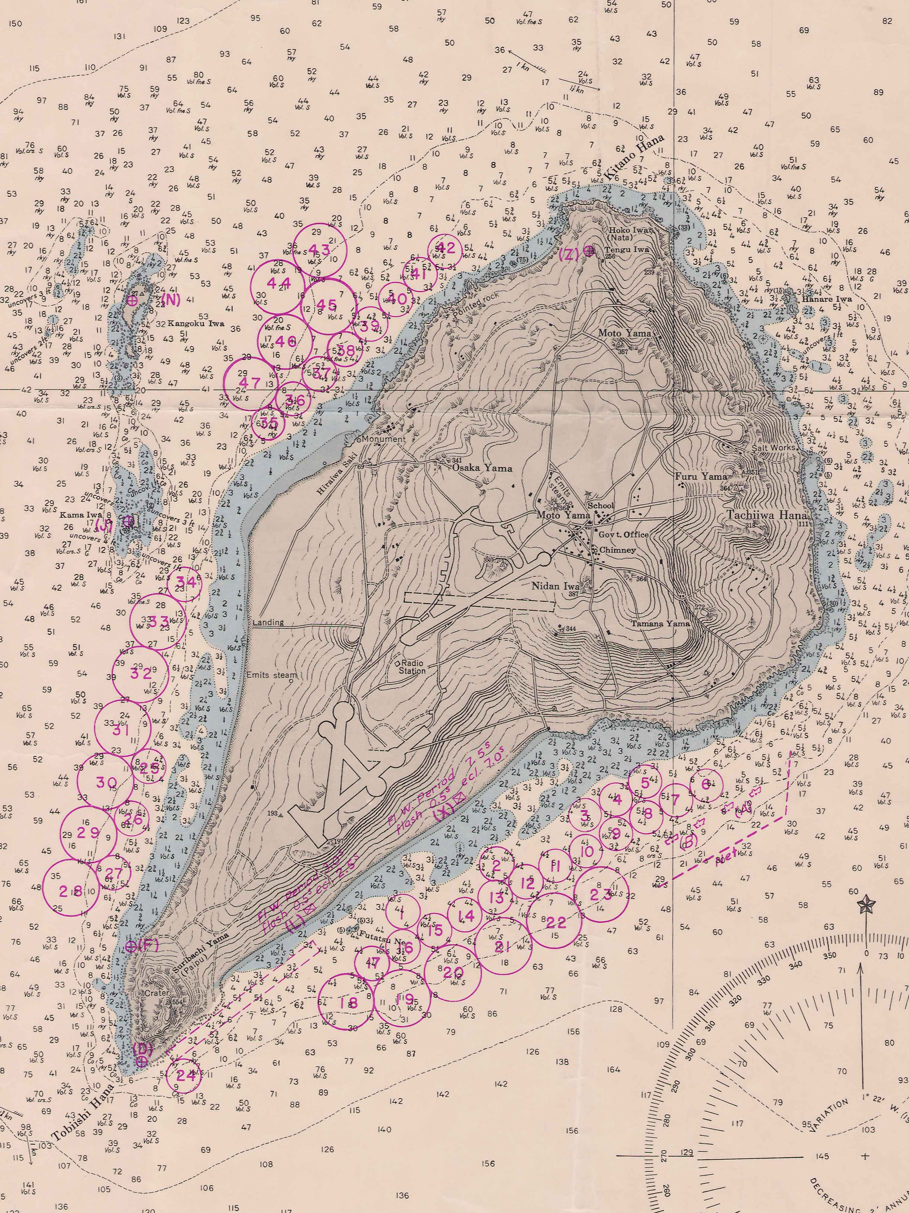
English: Depth chart from the Vicinity of Iwo Jima.
From the World War II: Iwo Jima Collection (COLL/3692) at the Marine Corps History Division OFFICIAL USMC PHOTOGRAPH |
| Date | |
| Source | https://www.flickr.com/photos/60868061@N04/50083342708/ |
| Author | Archives Branch, USMC History Division |
| Other versions |

.jpg&action=edit§ion=1)
Licensing
[edit].jpg&action=edit§ion=2)
This file is licensed under the Creative Commons Attribution 2.0 Generic license.
- You are free:
- to share – to copy, distribute and transmit the work
- to remix – to adapt the work
- Under the following conditions:
- attribution – You must give appropriate credit, provide a link to the license, and indicate if changes were made. You may do so in any reasonable manner, but not in any way that suggests the licensor endorses you or your use.
File history
Click on a date/time to view the file as it appeared at that time.
| Date/Time | Thumbnail | Dimensions | User | Comment | |
|---|---|---|---|---|---|
| current | 19:20, 26 September 2022 | | 3,009 × 4,013 (1.08 MB) | Ooligan (talk | contribs) | File:Iwo Jima, Anchorage Chart, 1944.jpg cropped 51 % horizontally, 52 % vertically using CropTool with lossless mode. |
You cannot overwrite this file.
File usage on Commons
The following page uses this file:
.jpg&oldid=787238138)