File:Iwate - Miyako - Taro -a- Tsunami heights -b- Part of the breakwater destroyed by the 2011 tsunami.jpg
Jump to navigation
Jump to search
Size of this preview: 390 × 600 pixels. Other resolutions: 156 × 240 pixels | 312 × 480 pixels | 499 × 768 pixels | 666 × 1,024 pixels | 1,292 × 1,987 pixels.
Original file (1,292 × 1,987 pixels, file size: 599 KB, MIME type: image/jpeg)
Captions
Captions
Add a one-line explanation of what this file represents
Summary
[edit]
| Description |
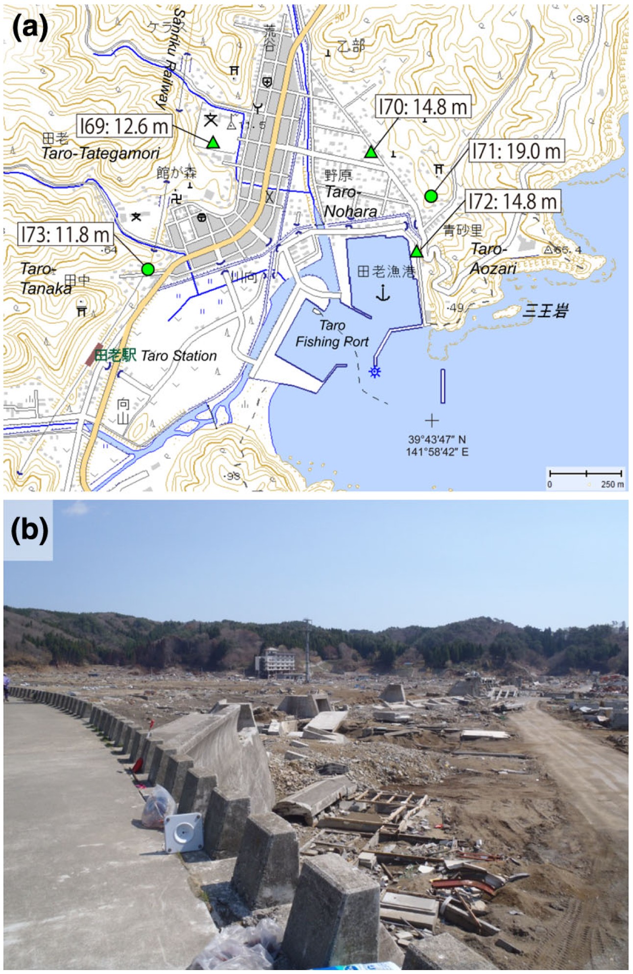
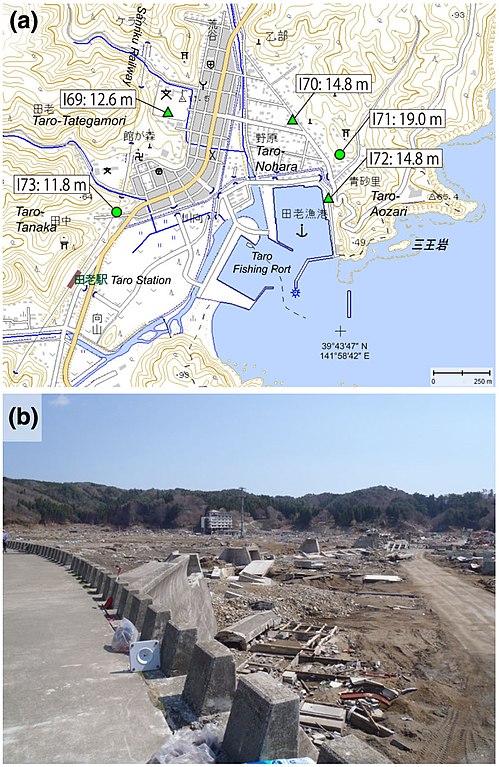
English: Source: Yoshinobu Tsuji, Kenji Satake, Takeo Ishibe, Tomoya Harada, Akihito Nishiyama, Satoshi Kusumoto: "Tsunami Heights along the Pacific Coast of Northern Honshu Recorded from the 2011 Tohoku", Pure and Applied Geophysics, 171, 12, (2014), pp. 3183–3215, DOI:10.1007/s00024-014-0779-x, online published on 19 March 2014. License: Creative Commons Attribution 4.0 International (CC BY 4.0). Here p. 3189, Figure 6.
Caption as given in the above cited source: "Figure 6 - a Tsunami heights at Taro-Tategamori (I69), Taro-Nohara (I70), Taro-Aozari (I71 and I72), and Taro-Tanaka (I73), Miyako City, Iwate Prefecture. The symbols and their meanings are the same as in Fig. 3. b Part of the breakwater destroyed by the 2011 tsunami. The building in the background is a hotel that the tsunami damaged up to the third floor (14.8 m; I70)" Context as given in the above cited source: "At Taro in Miyako City, coastal levees with a height of 10 m and a total length of *2.4 km had been constructed; however, the 2011 tsunami destroyed a portion of these coastal levees, and transported blocks and other debris from the structure more than 100 m inland (Fig. 6). Almost all houses and fishing facilities were swept away or were completely leveled. The first three floors of a hotel were severely damaged, indicating an inundation height of 14.8 m (I70). Tsunami traces on the wall of a Japan Fisheries Cooperatives icehouse indicate the same inundation height (I72). Runup heights of 11.8 m (I73) and 19.0 m (I71) were measured at the western and eastern part of the residential area, respectively. Tsunami trace at a middle school indicates an inundation height of 12.6 m (I69)." |
| Date | |
| Source | Yoshinobu Tsuji, Kenji Satake, Takeo Ishibe, Tomoya Harada, Akihito Nishiyama, Satoshi Kusumoto: "Tsunami Heights along the Pacific Coast of Northern Honshu Recorded from the 2011 Tohoku", Pure and Applied Geophysics, 171, 12, (2014), pp. 3183–3215, DOI:10.1007/s00024-014-0779-x, online published on 19 March 2014. License: Creative Commons Attribution 4.0 International (CC BY 4.0). Here p. 3189, Figure 6. |
| Author | Yoshinobu Tsuji, Kenji Satake, Takeo Ishibe, Tomoya Harada, Akihito Nishiyama, Satoshi Kusumoto: "Tsunami Heights along the Pacific Coast of Northern Honshu Recorded from the 2011 Tohoku", Pure and Applied Geophysics, 171, 12, (2014), pp. 3183–3215, DOI:10.1007/s00024-014-0779-x, online published on 19 March 2014. License: Creative Commons Attribution 4.0 International (CC BY 4.0). Here p. 3189, Figure 6. |
| Permission (Reusing this file) |
This file is licensed under the Creative Commons Attribution 4.0 International license.
|
Licensing
[edit]
This file is licensed under the Creative Commons Attribution 4.0 International license.
- You are free:
- to share – to copy, distribute and transmit the work
- to remix – to adapt the work
- Under the following conditions:
- attribution – You must give appropriate credit, provide a link to the license, and indicate if changes were made. You may do so in any reasonable manner, but not in any way that suggests the licensor endorses you or your use.
File history
Click on a date/time to view the file as it appeared at that time.
| Date/Time | Thumbnail | Dimensions | User | Comment | |
|---|---|---|---|---|---|
| current | 11:40, 16 August 2018 | | 1,292 × 1,987 (599 KB) | Anglo-Araneophilus~commonswiki (talk | contribs) | {{Information |description ={{en|1=Source: Yoshinobu Tsuji, Kenji Satake, Takeo Ishibe, Tomoya Harada, Akihito Nishiyama, Satoshi Kusumoto: "Tsunami Heights along the Pacific Coast of Northern Honshu Recorded from the 2011 Tohoku", Pure and Applied Geophysics, 171, 12, (2014), pp. 3183–3215, DOI:10.1007/s00024-014-0779-x, online published on 19 March 2014. License: Creative Commons Attribution 4.0 International (CC BY 4.0). Here p. 3189, Figure 6. Caption as given in the above cited source... |
You cannot overwrite this file.
File usage on Commons
There are no pages that use this file.
File usage on other wikis
The following other wikis use this file:
- Usage on de.wikipedia.org