File:Italy-0335 - Thermopolium (5153585519).jpg

Original file (4,288 × 2,848 pixels, file size: 13.06 MB, MIME type: image/jpeg)
Captions
Captions
Summary
[edit].jpg&action=edit§ion=1)
| Description |
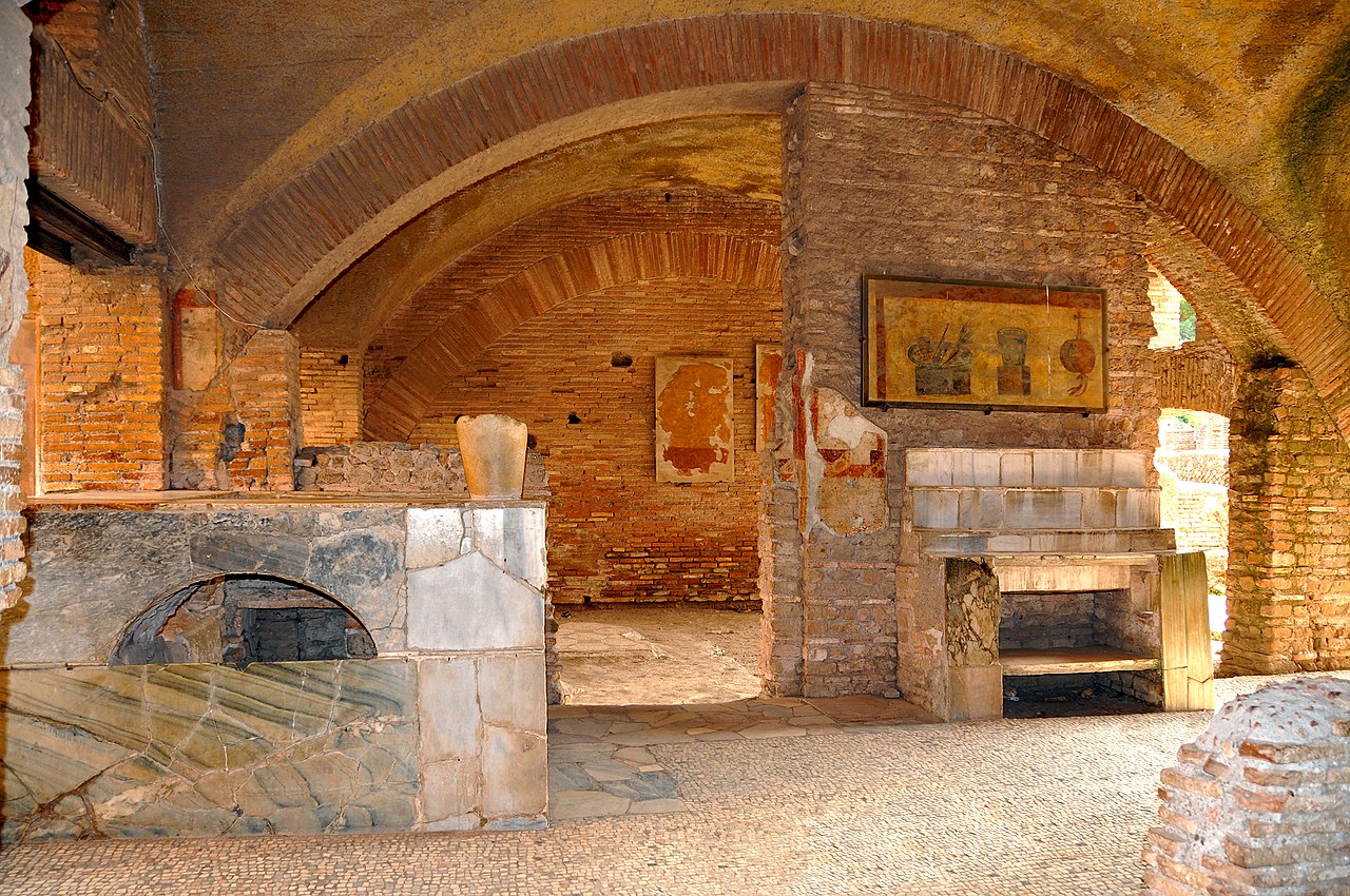
This shop, a Thermopolium, in a prime position near the Forum, sold hot food and drink. In the centre is the bar counter, with shelves and basins for washing dishes. To the right there is a kitchen with large storage jar and a built-in stove. To the rear, there was a small courtyard with a fountain and benches where customers could sit outside in fine weather. This is a really fantastic place and if you go to Rome it is a must to see. Many people say it is better than Pompeii as there are fewer restrictions. Ostia Antica is a large archeological site that was once the harbour city of ancient Rome, which is approximately 30 kilometres (19 mi) northeast of Rome. "Ostia" in Latin means "mouth" and is at the mouth of the River Tiber. Due to silting and a drop in sea level, the site now lies 3 kilometres (2 mi) from the sea. Founded in the 4th century B.C., as a military colony to guard the river mouth against seaborne invasions. Later, during the centuries Ostia gained prominence as the domestic landing for cargo boats. By the 2nd century A.D., it had become a flourishing commercial center inhabited by upwards of 100,000 people, whose apartment buildings, taverns, and grocery shops are still intact. Although Ostia now sprawls over 10,000 acres, around a main street that runs for more than a mile, it is still easy to imagine the local shepherds who for centuries sheltered their animals amongst its ruins, for they are an integral part of the tranquil Roman countryside. No modern houses, roads or telephone wires are visible on the horizon. |
| Date | |
| Source | Italy-0335 - Thermopolium |
| Author | Dennis Jarvis from Halifax, Canada |
| Camera location | | View this and other nearby images on: OpenStreetMap |
|---|
.jpg¶ms=041.758699_N_0012.288937_E_globe:Earth_type:camera_source:Flickr_&language=en)
Licensing
[edit].jpg&action=edit§ion=2)
- You are free:
- to share – to copy, distribute and transmit the work
- to remix – to adapt the work
- Under the following conditions:
- attribution – You must give appropriate credit, provide a link to the license, and indicate if changes were made. You may do so in any reasonable manner, but not in any way that suggests the licensor endorses you or your use.
- share alike – If you remix, transform, or build upon the material, you must distribute your contributions under the same or compatible license as the original.
| This image was originally posted to Flickr by archer10 (Dennis) 107M Views at https://flickr.com/photos/22490717@N02/5153585519 (archive). It was reviewed on 16 December 2017 by FlickreviewR 2 and was confirmed to be licensed under the terms of the cc-by-sa-2.0. |
File history
Click on a date/time to view the file as it appeared at that time.
| Date/Time | Thumbnail | Dimensions | User | Comment | |
|---|---|---|---|---|---|
| current | 12:50, 16 December 2017 | | 4,288 × 2,848 (13.06 MB) | Rudolphous (talk | contribs) | Transferred from Flickr via Flickr2Commons |
You cannot overwrite this file.
File usage on Commons
There are no pages that use this file.
.jpg&oldid=876156943)