File:Israel USA Locator.svg
Jump to navigation
Jump to search

Size of this PNG preview of this SVG file: 800 × 353 pixels. Other resolutions: 320 × 141 pixels | 640 × 283 pixels | 1,024 × 452 pixels | 1,280 × 565 pixels | 2,560 × 1,130 pixels | 940 × 415 pixels.
Original file (SVG file, nominally 940 × 415 pixels, file size: 1.76 MB)
Captions
Captions
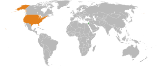
Map showing locations of Israel (green) and The USA (orange)
Summary
[edit]
| Description |
English: Map showing locations of Israel and USA |
| Date | 11 August 2011 (original upload date) |
| Source | File:BlankMap-World6, compact.svg |
| Author | The original uploader was Bazonka at English Wikipedia. |
Licensing
[edit]
This file is licensed under the Creative Commons Attribution-Share Alike 3.0 Unported license.
- You are free:
- to share – to copy, distribute and transmit the work
- to remix – to adapt the work
- Under the following conditions:
- attribution – You must give appropriate credit, provide a link to the license, and indicate if changes were made. You may do so in any reasonable manner, but not in any way that suggests the licensor endorses you or your use.
- share alike – If you remix, transform, or build upon the material, you must distribute your contributions under the same or compatible license as the original.
Original upload log
[edit]
Transferred from en.wikipedia to Commons by Luan using CommonsHelper.
The original description page was here. All following user names refer to en.wikipedia.
- 2011-08-11 17:13 Bazonka 940×415× (1849125 bytes) Map showing locations of Israel and USA
File history
Click on a date/time to view the file as it appeared at that time.
| Date/Time | Thumbnail | Dimensions | User | Comment | |
|---|---|---|---|---|---|
| current | 00:05, 24 October 2013 | | 940 × 415 (1.76 MB) | File Upload Bot (Magnus Manske) (talk | contribs) | Transfered from en.wikipedia by User:Luan using CommonsHelper |
You cannot overwrite this file.
File usage on Commons
The following page uses this file:
- File:Israel United States Locator.svg (file redirect)
File usage on other wikis
The following other wikis use this file:
- Usage on ar.wikipedia.org
- Usage on en.wikipedia.org
- Usage on eo.wikiquote.org
- Usage on fa.wikipedia.org
- Usage on fi.wikipedia.org
- Usage on hi.wikipedia.org
- Usage on it.wikipedia.org
- Usage on ms.wikipedia.org
- Usage on pt.wikipedia.org
- Usage on tr.wikipedia.org
- Usage on zh.wikipedia.org