File:Israel North Korea Locator.png
Jump to navigation
Jump to search

Size of this preview: 800 × 412 pixels. Other resolutions: 320 × 165 pixels | 640 × 329 pixels | 1,376 × 708 pixels.
Original file (1,376 × 708 pixels, file size: 75 KB, MIME type: image/png)
Captions
Captions
Add a one-line explanation of what this file represents
Summary
[edit]
| Description |
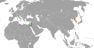
English: Map showing the location of Israel and North Korea, good for bilateral realtions articles about the two states. |
| Date | |
| Source | Own work |
| Author | FeydHuxtable |
created by me using paint.net and a public domain template, released with no rights.
Licensing
[edit]
| I, the copyright holder of this work, release this work into the public domain. This applies worldwide. In some countries this may not be legally possible; if so: I grant anyone the right to use this work for any purpose, without any conditions, unless such conditions are required by law. |
File history
Click on a date/time to view the file as it appeared at that time.
| Date/Time | Thumbnail | Dimensions | User | Comment | |
|---|---|---|---|---|---|
| current | 23:51, 6 June 2023 | | 1,376 × 708 (75 KB) | Aquintero82 (talk | contribs) | Updated map |
| 08:49, 28 July 2017 |  | 1,357 × 628 (41 KB) | E.F Edits (talk | contribs) | i | |
| 08:44, 28 July 2017 |  | 1,357 × 628 (41 KB) | E.F Edits (talk | contribs) | mark Israel | |
| 17:44, 29 June 2010 |  | 1,357 × 628 (57 KB) | FeydHuxtable~commonswiki (talk | contribs) | {{Information |Description={{en|1=Map showing the location of Israel and North Korea, good for bilateral realtions articles about the two states.}} |Source={{own}} |Author=FeydHuxtable |Date=2010-06-29 |Permission= |other_versions= } |
You cannot overwrite this file.
File usage on Commons
The following page uses this file:
File usage on other wikis
The following other wikis use this file:
- Usage on en.wikipedia.org
- Usage on es.wikipedia.org