File:Isle of Man railway map-de.svg
Jump to navigation
Jump to search

Size of this PNG preview of this SVG file: 654 × 600 pixels. Other resolutions: 262 × 240 pixels | 524 × 480 pixels | 838 × 768 pixels | 1,117 × 1,024 pixels | 2,234 × 2,048 pixels | 1,200 × 1,100 pixels.
Original file (SVG file, nominally 1,200 × 1,100 pixels, file size: 274 KB)
Captions
Captions
Add a one-line explanation of what this file represents
Summary
[edit]| Description |
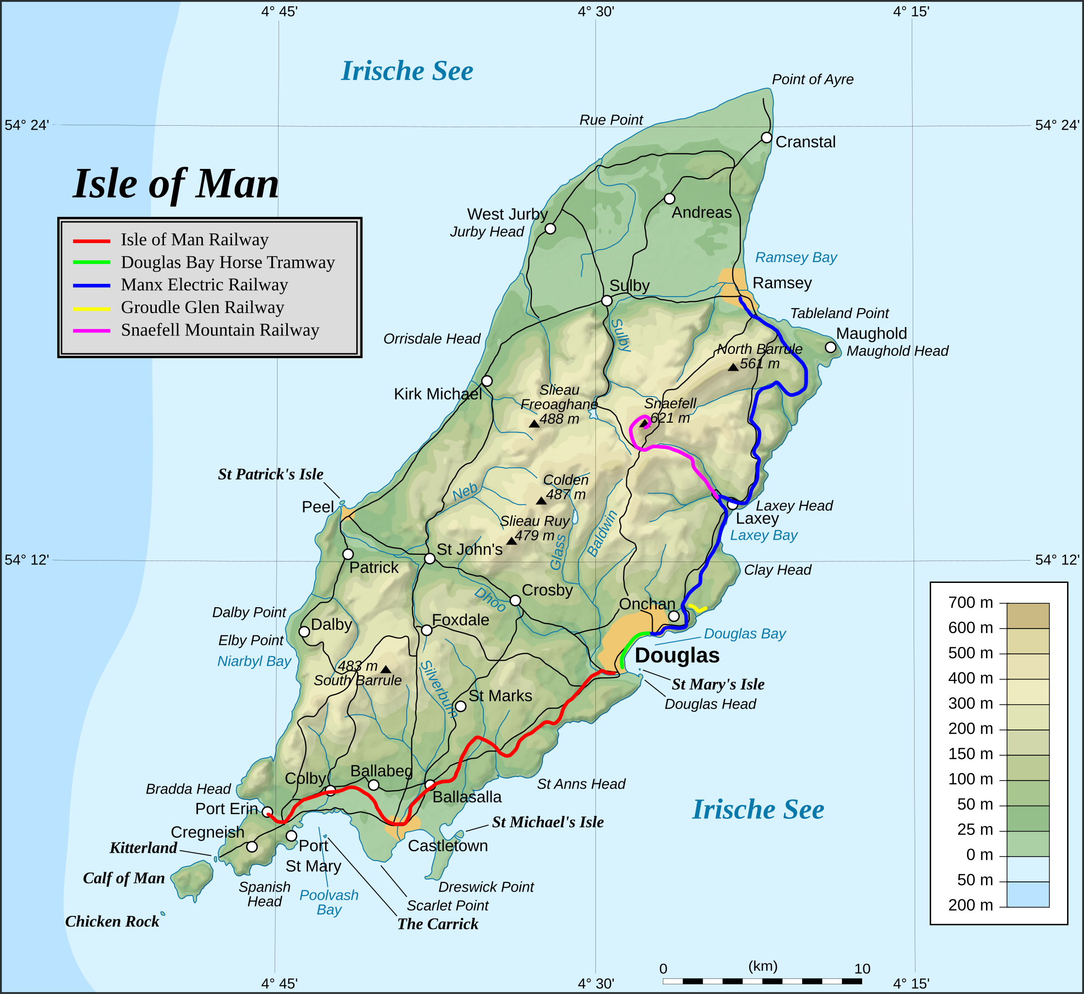
English: Railways and Tramways on the Isle of Man as of 2017 (Great Laxey Mine Railway omitted)
Deutsch: Schienenverkehr auf der Isle of Man im Jahr 2017 (ohne die Great Laxey Mine Railway) |
| Date | |
| Source |
This file was derived from: Isle of Man topographic map-de.svg |
| Author | Telford |
| SVG development |

Licensing
[edit]
I, the copyright holder of this work, hereby publish it under the following license:
This file is licensed under the Creative Commons Attribution-Share Alike 4.0 International license.
- You are free:
- to share – to copy, distribute and transmit the work
- to remix – to adapt the work
- Under the following conditions:
- attribution – You must give appropriate credit, provide a link to the license, and indicate if changes were made. You may do so in any reasonable manner, but not in any way that suggests the licensor endorses you or your use.
- share alike – If you remix, transform, or build upon the material, you must distribute your contributions under the same or compatible license as the original.
File history
Click on a date/time to view the file as it appeared at that time.
| Date/Time | Thumbnail | Dimensions | User | Comment | |
|---|---|---|---|---|---|
| current | 23:31, 24 December 2018 | | 1,200 × 1,100 (274 KB) | JoKalliauer (talk | contribs) | Defined Wiki-fonts according to c:Help:SVG#fallback |
| 17:34, 21 December 2018 |  | 1,200 × 1,100 (461 KB) | Telford (talk | contribs) | Legende gegenüber der Ursprungsversion intern noch mal anders formatiert, um Nebenwirkungen auf einige andere Texte in den PNG-Dateien zu vermeiden | |
| 03:35, 20 December 2018 |  | 512 × 469 (414 KB) | Majo statt Senf (talk | contribs) | Legende repariert | |
| 23:46, 19 December 2018 |  | 1,200 × 1,100 (459 KB) | Telford (talk | contribs) | {{Information |description ={{en|1=Railways and Tramways on the Isle of Man as of 2017 (Great Laxey Mine Railway omitted)}} {{de|1=Schienenverkehr auf der Isle of Man im Jahr 2017 (ohne die Great Laxey Mine Railway)}} |date =2017-11-28 |source ={{own}} |author =User:Telford }} Category:Rail transport maps of the Isle of Man |
You cannot overwrite this file.
File usage on Commons
The following 8 pages use this file:
- User:Chumwa/OgreBot/Potential transport maps/2018 December 11-20
- User:Chumwa/OgreBot/Potential transport maps/2018 December 21-31
- User:Chumwa/OgreBot/Public transport information/2018 December 11-20
- User:Chumwa/OgreBot/Public transport information/2018 December 21-31
- User:Chumwa/OgreBot/Transport Maps/2018 December 11-20
- User:Chumwa/OgreBot/Transport Maps/2018 December 21-31
- User:Chumwa/OgreBot/Travel and communication maps/2018 December 11-20
- User:Chumwa/OgreBot/Travel and communication maps/2018 December 21-31
File usage on other wikis
The following other wikis use this file:
- Usage on de.wikipedia.org
- Usage on ksh.wikipedia.org