File:Islam in India (2011).svg
Jump to navigation
Jump to search

Size of this PNG preview of this SVG file: 531 × 600 pixels. Other resolutions: 212 × 240 pixels | 425 × 480 pixels | 680 × 768 pixels | 906 × 1,024 pixels | 1,813 × 2,048 pixels | 1,643 × 1,856 pixels.
Original file (SVG file, nominally 1,643 × 1,856 pixels, file size: 257 KB)
Captions
Captions
Add a one-line explanation of what this file represents
Summary
[edit].svg&action=edit§ion=1)
| Description |
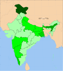
English: A map showing the Islam distribution within India by state or union territory, according to the 2011 census. The colour scheme used in this map may be used for any past or future censuses of India.
>50%
40–50%
30–40%
20–30%
10–20%
0–10% |
| Date | |
| Source |
This file was derived from: India district map (claimed).svg |
| Author | Sbb1413 (derived work) |
.svg)
Licensing
[edit].svg&action=edit§ion=2)
This file is licensed under the Creative Commons Attribution-Share Alike 3.0 Unported license.
- You are free:
- to share – to copy, distribute and transmit the work
- to remix – to adapt the work
- Under the following conditions:
- attribution – You must give appropriate credit, provide a link to the license, and indicate if changes were made. You may do so in any reasonable manner, but not in any way that suggests the licensor endorses you or your use.
- share alike – If you remix, transform, or build upon the material, you must distribute your contributions under the same or compatible license as the original.
File history
Click on a date/time to view the file as it appeared at that time.
| Date/Time | Thumbnail | Dimensions | User | Comment | |
|---|---|---|---|---|---|
| current | 13:18, 11 July 2023 | | 1,643 × 1,856 (257 KB) | Sbb1413 (talk | contribs) | removing title to make it language-neutral |
| 13:03, 11 July 2023 |  | 1,643 × 1,856 (258 KB) | Sbb1413 (talk | contribs) | Uploaded a work by {{U|Sbb1413}} (derived work) from {{derived from|India district map (claimed).svg}} with UploadWizard |
You cannot overwrite this file.
File usage on Commons
The following 3 pages use this file:
.svg&oldid=782471826)