File:Isartor Freising Ostseite.png
Jump to navigation
Jump to search

Size of this preview: 685 × 599 pixels. Other resolutions: 274 × 240 pixels | 549 × 480 pixels | 878 × 768 pixels | 1,171 × 1,024 pixels | 2,341 × 2,048 pixels | 3,408 × 2,981 pixels.
Original file (3,408 × 2,981 pixels, file size: 10.84 MB, MIME type: image/png)
Captions
Captions
Add a one-line explanation of what this file represents
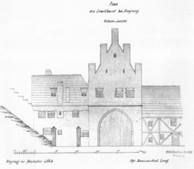
| Description | Ostseite des Freisinger Isartores |
| Date | |
| Source | Britta von Rettberg: Freising-Stadttopographie und Denkmalpflege. Imhof, Petersberg 2009, ISBN 978-3865683540 |
| Author | kgl. Baumeister Lang |
| Object location | | View this and other nearby images on: OpenStreetMap |
|---|
|
This work is in the public domain in its country of origin and other countries and areas where the copyright term is the author's life plus 70 years or fewer. | |
| This file has been identified as being free of known restrictions under copyright law, including all related and neighboring rights. | |
File history
Click on a date/time to view the file as it appeared at that time.
| Date/Time | Thumbnail | Dimensions | User | Comment | |
|---|---|---|---|---|---|
| current | 15:13, 10 January 2013 | | 3,408 × 2,981 (10.84 MB) | Vuxi (talk | contribs) | {{Information |Description= Ostseite des Freisinger Isartores |Source= Britta von Rettberg: Freising-Stadttopographie und Denkmalpflege. Imhof, Petersberg 2009, ISBN 978-3865683540 |Date= 1863 |Author= kgl. Baumeister Lang |Permission= |other_versions=... |
You cannot overwrite this file.
File usage on Commons
The following page uses this file:
File usage on other wikis
The following other wikis use this file:
- Usage on de.wikipedia.org
- Usage on www.wikidata.org