File:Ireland map County Dublin Fingal.png
Jump to navigation
Jump to search
No higher resolution available.
Ireland_map_County_Dublin_Fingal.png (163 × 120 pixels, file size: 4 KB, MIME type: image/png)
Captions
Captions
Add a one-line explanation of what this file represents
Summary
[edit]
| Description |
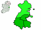
English: County Dublin map with inset location on island of Ireland. Also administrative divisions, with Fingal highlighted. |
| Date | 9 November 2004 (original upload date) |
| Source | Transferred from en.wikipedia to Commons by Common Good using CommonsHelper. |
| Author | The original uploader was Zoney at English Wikipedia. |
Licensing
[edit]
| This file is licensed under the Creative Commons Attribution-Share Alike 3.0 Unported license. Subject to disclaimers. | ||
| ||
| This licensing tag was added to this file as part of the GFDL licensing update. |

|
Permission is granted to copy, distribute and/or modify this document under the terms of the GNU Free Documentation License, Version 1.2 or any later version published by the Free Software Foundation; with no Invariant Sections, no Front-Cover Texts, and no Back-Cover Texts. A copy of the license is included in the section entitled GNU Free Documentation License. Subject to disclaimers. |
Original upload log
[edit]
The original description page was here. All following user names refer to en.wikipedia.
- 2004-11-09 23:35 Zoney 163×120× (4361 bytes) County Dublin map with inset location on island of Ireland. Also administrative divisions, with Fingal highlighted. {{GFDL}}
File history
Click on a date/time to view the file as it appeared at that time.
| Date/Time | Thumbnail | Dimensions | User | Comment | |
|---|---|---|---|---|---|
| current | 20:22, 19 March 2009 | | 163 × 120 (4 KB) | File Upload Bot (Magnus Manske) (talk | contribs) | {{BotMoveToCommons|en.wikipedia|year={{subst:CURRENTYEAR}}|month={{subst:CURRENTMONTHNAME}}|day={{subst:CURRENTDAY}}}} {{Information |Description={{en|County Dublin map with inset location on island of Ireland. Also administrative divisions, with Fingal |
You cannot overwrite this file.
File usage on Commons
There are no pages that use this file.
File usage on other wikis
The following other wikis use this file:
- Usage on de.wikipedia.org
- Usage on en.wikipedia.org
- Usage on fy.wikipedia.org
- Usage on ga.wikipedia.org
- Usage on ru.wikipedia.org
- Usage on uk.wikipedia.org
- Usage on vi.wikipedia.org
- Usage on zh.wikipedia.org