File:Ireland location map Midlands.svg
Jump to navigation
Jump to search

Size of this PNG preview of this SVG file: 481 × 599 pixels. Other resolutions: 192 × 240 pixels | 385 × 480 pixels | 616 × 768 pixels | 822 × 1,024 pixels | 1,643 × 2,048 pixels | 1,450 × 1,807 pixels.
Original file (SVG file, nominally 1,450 × 1,807 pixels, file size: 1.98 MB)
Captions
Captions
Add a one-line explanation of what this file represents
| Description |
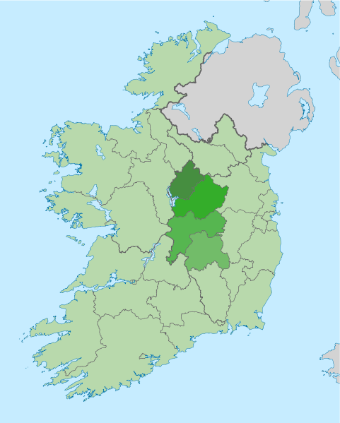
English: The island of Ireland, showing international border between Ireland and Northern Ireland, traditional provinces, traditional counties, and local authority areas in Ireland and Northern Ireland. Highlighted in the Midlands region of Ireland. |
| Date | (UTC) |
| Source | |
| Author |
|
| This is a retouched picture, which means that it has been digitally altered from its original version. Modifications: Midlands region highlighted. The original can be viewed here: Island of Ireland location map.svg:
|
I, the copyright holder of this work, hereby publish it under the following license:
This file is licensed under the Creative Commons Attribution-Share Alike 3.0 Unported license.
- You are free:
- to share – to copy, distribute and transmit the work
- to remix – to adapt the work
- Under the following conditions:
- attribution – You must give appropriate credit, provide a link to the license, and indicate if changes were made. You may do so in any reasonable manner, but not in any way that suggests the licensor endorses you or your use.
- share alike – If you remix, transform, or build upon the material, you must distribute your contributions under the same or compatible license as the original.
Original upload log
[edit]
This image is a derivative work of the following images:
- File:Island_of_Ireland_location_map.svg licensed with Cc-by-sa-3.0
- 2010-03-06T20:43:33Z Rannpháirtí anaithnid 1450x1807 (679207 Bytes) Fix incorrectly coloured isands.
- 2010-03-03T22:19:29Z Rannpháirtí anaithnid 1450x1807 (679744 Bytes) {{Information |Description={{de|Positionskarte von [[:de:Irland|Irland]]}} Quadratische Plattkarte, N-S-Streckung 170 %. Geographische Begrenzung der Karte: * N: 55.6° N * S: 51.2° N * W: 11.0° W * O: 5.0° W {{en|Location
Uploaded with derivativeFX
File history
Click on a date/time to view the file as it appeared at that time.
| Date/Time | Thumbnail | Dimensions | User | Comment | |
|---|---|---|---|---|---|
| current | 11:05, 16 September 2010 | | 1,450 × 1,807 (1.98 MB) | Mabuska (talk | contribs) | Different shades for each county |
| 11:02, 14 September 2010 |  | 1,450 × 1,807 (1.28 MB) | Mabuska (talk | contribs) | Coloured external entities appropraitely to prevent distraction from subject | |
| 11:29, 29 August 2010 |  | 1,450 × 1,807 (867 KB) | Mabuska (talk | contribs) | Added Wales which for some reason is missing but is in original Ireland location map | |
| 10:40, 29 August 2010 |  | 1,450 × 1,807 (815 KB) | Mabuska (talk | contribs) | Updated colour and borders - map is about modern internal RoI admnistrative counties | |
| 17:37, 17 August 2010 |  | 1,450 × 1,807 (831 KB) | Mabuska (talk | contribs) | Removed tiny portion of Galway that was shaded dark green. | |
| 16:39, 17 August 2010 |  | 1,450 × 1,807 (831 KB) | Mabuska (talk | contribs) | {{Information |Description={{en|The island of Ireland, showing international border between Northern Ireland and Republic of Ireland, traditional provinces, traditional counties, and local authority areas in the Republic of Ireland and Northern Ireland. H |
You cannot overwrite this file.
File usage on Commons
There are no pages that use this file.
File usage on other wikis
The following other wikis use this file:
- Usage on de.wikipedia.org
- Usage on en.wikipedia.org