File:Ionian Revolt Campaign Map-fr.svg
Jump to navigation
Jump to search

Size of this PNG preview of this SVG file: 454 × 599 pixels. Other resolutions: 182 × 240 pixels | 364 × 480 pixels | 582 × 768 pixels | 776 × 1,024 pixels | 1,552 × 2,048 pixels | 1,330 × 1,755 pixels.
Original file (SVG file, nominally 1,330 × 1,755 pixels, file size: 1,018 KB)
Captions
Captions
Add a one-line explanation of what this file represents
Summary
[edit]| Description |
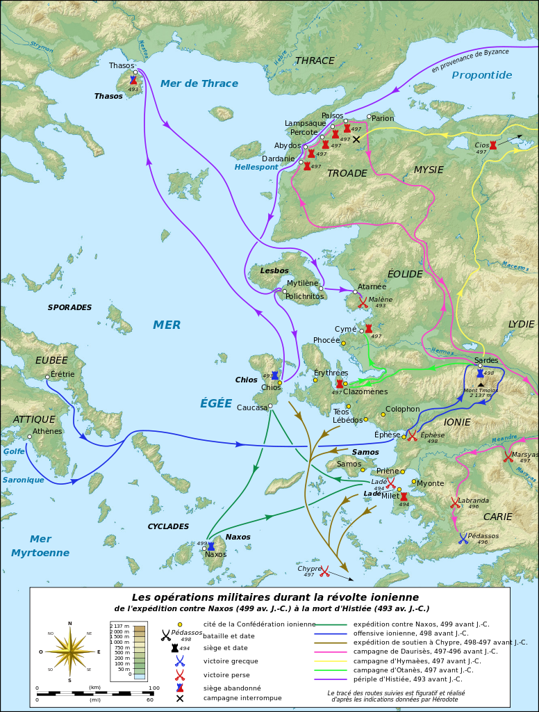
English: Map in French of the military operations during the Ionian Revolt which will lead to the Greco–Persian Wars.
Notes:
Français : Carte en français des opérations militaires durant la révolte de l'Ionie qui va déclencher les Guerres médiques. Notes :
UTM projection – WGS84 datum |
||
| Date | |||
| Source |
Own work
|
||
| Author | Eric Gaba (Sting - fr:Sting) | ||
| Permission (Reusing this file) |
|
||
| Other versions |
|


|
This SVG file contains embedded text that can be translated into your language, using any capable SVG editor, text editor or the SVG Translate tool. For more information see: About translating SVG files. |
Licensing
[edit]
I, the copyright holder of this work, hereby publish it under the following licenses:

|
Permission is granted to copy, distribute and/or modify this document under the terms of the GNU Free Documentation License, Version 1.2 or any later version published by the Free Software Foundation; with no Invariant Sections, no Front-Cover Texts, and no Back-Cover Texts. A copy of the license is included in the section entitled GNU Free Documentation License. |
This file is licensed under the Creative Commons Attribution-Share Alike 3.0 Unported license.
- You are free:
- to share – to copy, distribute and transmit the work
- to remix – to adapt the work
- Under the following conditions:
- attribution – You must give appropriate credit, provide a link to the license, and indicate if changes were made. You may do so in any reasonable manner, but not in any way that suggests the licensor endorses you or your use.
- share alike – If you remix, transform, or build upon the material, you must distribute your contributions under the same or compatible license as the original.
You may select the license of your choice.
File history
Click on a date/time to view the file as it appeared at that time.
| Date/Time | Thumbnail | Dimensions | User | Comment | |
|---|---|---|---|---|---|
| current | 21:20, 16 July 2010 | | 1,330 × 1,755 (1,018 KB) | Sting (talk | contribs) | Embedded color profile |
| 12:58, 27 June 2009 |  | 1,330 × 1,755 (1.01 MB) | Sting (talk | contribs) | Oups! (some of the corrections haven't been saved) | |
| 12:36, 27 June 2009 |  | 1,330 × 1,755 (1 MB) | Sting (talk | contribs) | Correction of the Antic shoreline around Miletus and Ephesus ; more precise position of some polis | |
| 19:10, 26 June 2009 |  | 1,330 × 1,755 (1.01 MB) | Sting (talk | contribs) | == Summary == {{Information| |Description={{en|Map in French of the military operations during the Ionian Revolt which will lead to the Greco–Persian Wars.<br/>''Notes:''<br/> *''The background map is a |
You cannot overwrite this file.
File usage on Commons
The following 5 pages use this file:
File usage on other wikis
The following other wikis use this file:
- Usage on fa.wikipedia.org
- Usage on fr.wikipedia.org