File:Intercommunalités Corse-du-Sud 2017.svg
Jump to navigation
Jump to search

Size of this PNG preview of this SVG file: 422 × 599 pixels. Other resolutions: 169 × 240 pixels | 338 × 480 pixels | 541 × 768 pixels | 721 × 1,024 pixels | 1,443 × 2,048 pixels | 496 × 704 pixels.
Original file (SVG file, nominally 496 × 704 pixels, file size: 185 KB)
Captions
Captions
Add a one-line explanation of what this file represents
Summary
[edit]
| Description |
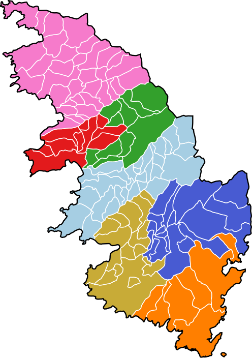
Français : Carte des intercommunalités du département de la Corse-du-Sud, France. Composition au 1er janvier 2017 :
English: Map of groups of communes in Corse-du-Sud department, France. Composition on 1st January 2017. |
| Date | |
| Source | Own work |
| Author | Pymouss |
| Permission (Reusing this file) |
Based on GEOFLA® 2016 v2.2 Communes France Métropolitaine, a work of Institut géographique national, licensed under the Licence Ouverte. |
Licensing
[edit]
I, the copyright holder of this work, hereby publish it under the following license:
This file is licensed under the Creative Commons Attribution-Share Alike 4.0 International license.
- You are free:
- to share – to copy, distribute and transmit the work
- to remix – to adapt the work
- Under the following conditions:
- attribution – You must give appropriate credit, provide a link to the license, and indicate if changes were made. You may do so in any reasonable manner, but not in any way that suggests the licensor endorses you or your use.
- share alike – If you remix, transform, or build upon the material, you must distribute your contributions under the same or compatible license as the original.
File history
Click on a date/time to view the file as it appeared at that time.
| Date/Time | Thumbnail | Dimensions | User | Comment | |
|---|---|---|---|---|---|
| current | 22:08, 21 May 2017 | | 496 × 704 (185 KB) | Pymouss (talk | contribs) | == {{int:filedesc}} == {{Information |description={{fr|1=Carte des intercommunalités du département de la Corse-du-Sud, France. Composition au 1{{er}} janvier 2017 : *{{legend|#e31a1c|fr:Communauté d'agglomération du Pays ajaccien}} *{{legend... |
You cannot overwrite this file.
File usage on Commons
The following 7 pages use this file:
- File:Localisation CA du Pays ajaccien en Corse-du-Sud, France.svg
- File:Localisation CC de l'Alta Rocca en Corse-du-Sud, France.svg
- File:Localisation CC de l'Ouest Corse en Corse-du-Sud, France.svg
- File:Localisation CC de la Haute Vallée de la Gravona en Corse-du-Sud, France.svg
- File:Localisation CC de la Pieve de l'Ornano en Corse-du-Sud, France.svg
- File:Localisation CC du Sartenais-Valinco en Corse-du-Sud, France.svg
- File:Localisation CC du Sud Corse en Corse-du-Sud, France.svg
File usage on other wikis
The following other wikis use this file:
- Usage on fr.wikipedia.org
- Usage on lij.wikipedia.org