File:Installationen auf dem Hiroshima-Hain Hannover.jpg
Jump to navigation
Jump to search

Size of this preview: 800 × 501 pixels. Other resolutions: 320 × 200 pixels | 640 × 401 pixels | 1,024 × 641 pixels | 1,280 × 801 pixels | 2,362 × 1,479 pixels.
Original file (2,362 × 1,479 pixels, file size: 4.75 MB, MIME type: image/jpeg)
Captions
Captions
Add a one-line explanation of what this file represents
Summary
[edit]
| Description |
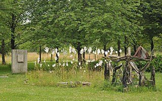
Deutsch: Der Hiroshima-Hain in Hannover wurde 1987 auf dem Gelände der früheren Pferderennbahn Alte Bult an der Eilenriede im Stadtteil Südstadt-Bult angelegt. Die 110 gepflanzten Kirschbäume erinnern an die 110.000 Soforttoten während des Atombombenabwurfs über Hiroshima am 6. August 1945. Auf dem heutigen Landschaftsschutzgebiet wurde 1992 ein Gedenkstein aus einer Steinplatte aufgestellt, die am 6. August 1945 zum Straßenbahnnetz von Hiroshima gehörte. Darauf wurde ein Relief der Friedensgöttin Kannon aufgebracht. Das aus Baumstämmen ausgelegte CND-Symbol zeigt das Zeichen für die atomare Abrüstung. Dort erinnern rings um das Modell des Genbaku Domes herum die weißen Hände, die sich zum Himmel ausstrecken, an das Leid der betroffenen Menschen. Klaus-Dieter Kappenberg gestaltete diese Installation im Jahr 2000. |
| Date | |
| Source | Own work |
| Author | Michael Gäbler |
| Attribution (required by the license) | © Michael Gäbler / Wikimedia Commons / |
| Camera location | | View this and other nearby images on: OpenStreetMap |
|---|
Licensing
[edit]
Michael Gäbler, the copyright holder of this work, hereby publishes it under the following license:
This file is licensed under the Creative Commons Attribution-Share Alike 3.0 Unported license.
Attribution: Michael Gäbler
- You are free:
- to share – to copy, distribute and transmit the work
- to remix – to adapt the work
- Under the following conditions:
- attribution – You must give appropriate credit, provide a link to the license, and indicate if changes were made. You may do so in any reasonable manner, but not in any way that suggests the licensor endorses you or your use.
- share alike – If you remix, transform, or build upon the material, you must distribute your contributions under the same or compatible license as the original.
|
The photographical reproduction of this work is covered under the article § 59 of the German copyright law, which states that "It shall be permissible to reproduce, by painting, drawing, photography or cinematography, works which are permanently located on public ways, streets or places and to distribute and publicly communicate such copies. For works of architecture, this provision shall be applicable only to the external appearance."
As with all other “limits of copyright by legally permitted uses”, no changes to the actual work are permitted under § 62 of the German copyright law (UrhG). See Commons:Copyright rules by territory/Germany#Freedom of panorama for more information.
|
File history
Click on a date/time to view the file as it appeared at that time.
| Date/Time | Thumbnail | Dimensions | User | Comment | |
|---|---|---|---|---|---|
| current | 23:07, 11 April 2015 | | 2,362 × 1,479 (4.75 MB) | Michael Gäbler (talk | contribs) | =={{int:filedesc}}== {{Information |description= {{de|1=Der Hiroshima-Gedenkhain in Hannover wurde 1987 auf dem Gelände der früheren ''Pferderennbahn Alte Bult'' an der Eilenriede im Stadtteil [[:de:Han... |
You cannot overwrite this file.
File usage on Commons
The following page uses this file:
File usage on other wikis
The following other wikis use this file:
- Usage on de.wikipedia.org