File:Indo-European branches map.svg
Jump to navigation
Jump to search

Size of this PNG preview of this SVG file: 400 × 400 pixels. Other resolutions: 240 × 240 pixels | 480 × 480 pixels | 768 × 768 pixels | 1,024 × 1,024 pixels | 2,048 × 2,048 pixels.
Original file (SVG file, nominally 400 × 400 pixels, file size: 749 KB)
Captions
Captions
Add a one-line explanation of what this file represents
Any autoconfirmed user can overwrite this file from the same source. Please ensure that overwrites comply with the guideline.
Summary
[edit]
| Description |
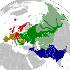
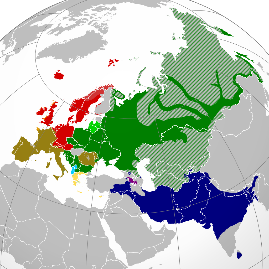
English: A map showing the approximate present-day distribution of the Indo-European branches within their homelands of Europe and Asia. The following legend is given in the chronological order of the earliest surviving written attestations of each branch:
Non-Indo-European languages
Dotted/striped areas indicate where multilingualism is common (more visible upon full enlargement of the map).Polski: Współczesne rozmieszczenie głównych gałęzi języków indoeuropejskich w Eurazji. Obszary kreskowane i kropkowane (lepiej widoczne w powiększeniu) oznaczają powszechną wielojęzyczność ich mieszkańców.
|
| Date | |
| Source |
English: Indo-European branches map.png
Polski: Own work based on: Indo-European branches map.png by Hayden120; za: Approximate locations of Indo-European languages in contemporary Eurasia, Britannica Kids |
| Author |
English: Indo-European branches map.png: Hayden120
Polski: Alphathon |
.svg)
Licensing
[edit]
I, the copyright holder of this work, hereby publish it under the following licenses:
This file is licensed under the Creative Commons Attribution-Share Alike 3.0 Unported license.
- You are free:
- to share – to copy, distribute and transmit the work
- to remix – to adapt the work
- Under the following conditions:
- attribution – You must give appropriate credit, provide a link to the license, and indicate if changes were made. You may do so in any reasonable manner, but not in any way that suggests the licensor endorses you or your use.
- share alike – If you remix, transform, or build upon the material, you must distribute your contributions under the same or compatible license as the original.

|
Permission is granted to copy, distribute and/or modify this document under the terms of the GNU Free Documentation License, Version 1.2 or any later version published by the Free Software Foundation; with no Invariant Sections, no Front-Cover Texts, and no Back-Cover Texts. A copy of the license is included in the section entitled GNU Free Documentation License. |
You may select the license of your choice.
File history
Click on a date/time to view the file as it appeared at that time.
| Date/Time | Thumbnail | Dimensions | User | Comment | |
|---|---|---|---|---|---|
| current | 16:20, 5 June 2024 | | 400 × 400 (749 KB) | Golden (talk | contribs) | update Karabakh |
| 17:12, 7 August 2021 |  | 400 × 400 (749 KB) | Demetrios1993 (talk | contribs) | Reverted to version as of 12:41, 27 August 2016 (UTC) There seems to be an issue with my file, thus i am self-rv back to the previous version for the time being. | |
| 16:41, 7 August 2021 |  | 2,934 × 2,938 (2.57 MB) | Demetrios1993 (talk | contribs) | Updated map; same as it is for the PNG version. | |
| 12:41, 27 August 2016 |  | 400 × 400 (749 KB) | Rob984 (talk | contribs) | Georgia and Azerbaijan aren't majority multilingual any longer. Many, but not all, in older generations speak Russian from the Soviet era but now English is taught mainly in place of Russian. And we aren't showing Finland as multilingual in a Germanic... | |
| 05:44, 13 July 2016 |  | 400 × 400 (753 KB) | Unghhg (talk | contribs) | Reverted to version as of 03:51, 2 February 2016 (UTC) | |
| 14:50, 24 February 2016 |  | 400 × 400 (755 KB) | Ercwlff (talk | contribs) | for what reasons? | |
| 03:51, 2 February 2016 |  | 400 × 400 (753 KB) | Turnless (talk | contribs) | Reverted to version as of 17:01, 20 October 2015 (UTC) | |
| 17:10, 19 January 2016 |  | 400 × 400 (755 KB) | Ercwlff (talk | contribs) | fix Georgia | |
| 17:01, 20 October 2015 |  | 400 × 400 (753 KB) | Alphathon (talk | contribs) | Cropped | |
| 16:56, 20 October 2015 |  | 453 × 400 (753 KB) | Alphathon (talk | contribs) | {{Information |Description={{en|A map showing the approximate present-day distribution of the Indo-European branches within their homelands of Europe and Asia. The following legend is given in the chronological order of... |
You cannot overwrite this file.
File usage on Commons
The following 9 pages use this file:
- User:Chumwa/OgreBot/Travel and communication maps/2016 August 21-31
- User:Chumwa/OgreBot/Travel and communication maps/2016 February 1-9
- User:Chumwa/OgreBot/Travel and communication maps/2016 February 20-29
- User:Chumwa/OgreBot/Travel and communication maps/2016 January 11-20
- User:Chumwa/OgreBot/Travel and communication maps/2016 July 11-20
- User:Chumwa/OgreBot/Travel and communication maps/2021 August 1-10
- User:Chumwa/OgreBot/Travel and communication maps/2024 June 1-10
- File:Indo-European branches map.png
- File:Indo-European steppe homeland map.svg
File usage on other wikis
The following other wikis use this file:
- Usage on af.wikipedia.org
- Usage on am.wikipedia.org
- Usage on ar.wikipedia.org
- Usage on azb.wikipedia.org
- Usage on az.wikipedia.org
- Usage on bcl.wikipedia.org
- Usage on bh.wikipedia.org
- Usage on bn.wikipedia.org
- Usage on bs.wikipedia.org
- Usage on ca.wikipedia.org
- Usage on ckb.wikipedia.org
- Usage on cs.wikipedia.org
- Usage on dty.wikipedia.org
- Usage on en.wikipedia.org
- Selonian language
- Semigallian language
- Bashkardi language
- List of Indo-European languages
- West Iberian languages
- Indogermanisches etymologisches Wörterbuch
- Aimaq dialect
- Alpha privative
- Southwestern Brittonic languages
- User:Irpen/sb
- Frahang-i Oim-evak
- Template:IndoEuropean-lang-stub
- Dzūkian dialect
- Encyclopedia of Indo-European Culture
- Grundriß der vergleichenden Grammatik der indogermanischen Sprachen
- *kʷetwóres rule
- Digor Ossetian
- Iron Ossetian
- TITUS (project)
- Pisidian language
- Kamviri dialect
- Suri (flower)
- Sant Bhasha
- Tregami language
- Kalasha-ala
- Wasi-wari
- Borujerdi dialect
- Kamkata-vari language
- Mumviri dialect
- Vanji language
- Sivandi language
- Unified Cornish
- Semnani languages
- Sangsari language
View more global usage of this file.