File:India Madhya Pradesh relief map.svg
Jump to navigation
Jump to search

Size of this PNG preview of this SVG file: 800 × 519 pixels. Other resolutions: 320 × 208 pixels | 640 × 415 pixels | 1,024 × 665 pixels | 1,280 × 831 pixels | 2,560 × 1,661 pixels | 1,473 × 956 pixels.
Original file (SVG file, nominally 1,473 × 956 pixels, file size: 2.22 MB)
Captions
Captions
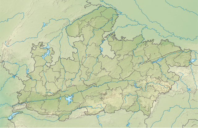
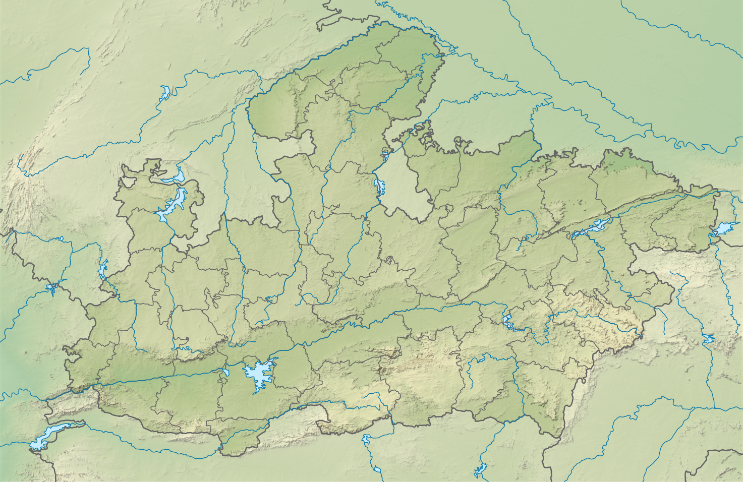
Relief map of Madhya Pradesh
Summary
[edit]
| Description |
English: Relief map of Madhya Pradesh. Elevation data from STRM30 and rivers data from GSHHS. |
| Date | |
| Source | Own work based on Madhya Pradesh location map.svg |
| Author | Own work |
Licensing
[edit]
This file is licensed under the Creative Commons Attribution-Share Alike 4.0 International license.
- You are free:
- to share – to copy, distribute and transmit the work
- to remix – to adapt the work
- Under the following conditions:
- attribution – You must give appropriate credit, provide a link to the license, and indicate if changes were made. You may do so in any reasonable manner, but not in any way that suggests the licensor endorses you or your use.
- share alike – If you remix, transform, or build upon the material, you must distribute your contributions under the same or compatible license as the original.
File history
Click on a date/time to view the file as it appeared at that time.
| Date/Time | Thumbnail | Dimensions | User | Comment | |
|---|---|---|---|---|---|
| current | 04:23, 16 May 2021 | | 1,473 × 956 (2.22 MB) | C1MM (talk | contribs) | Made relief stand out better |
| 06:53, 1 February 2021 |  | 1,829 × 1,187 (2.68 MB) | C1MM (talk | contribs) | Increased colour contrast | |
| 05:29, 24 October 2020 |  | 1,829 × 1,187 (4.31 MB) | C1MM (talk | contribs) | Uploaded a work by Own work based on Nzeemin from Own work based on Madhya Pradesh location map.svg with UploadWizard |
You cannot overwrite this file.
File usage on Commons
The following page uses this file:
- File:Madhya Pradesh relief map.svg (file redirect)
File usage on other wikis
The following other wikis use this file:
- Usage on ban.wikipedia.org
- Usage on bn.wikipedia.org
- Usage on en.wikipedia.org
- Bhopal
- Sanchi
- Khajuraho Group of Monuments
- Bhimbetka rock shelters
- Vidisha
- Chanderi
- Amarkantak
- Bagh Caves
- Udayagiri Caves
- Bharhut
- Gandhi Sagar Dam
- Gwalior Fort
- Pashupatinath Temple, Mandsaur
- Tawa Reservoir
- Kuno National Park
- Eran
- 1997 Jabalpur earthquake
- Mandsaur Fort
- Achanakmar Wildlife Sanctuary
- Bateshwar Hindu temples, Madhya Pradesh
- Tiki Formation
- Dhupgarh
- Rewa Plateau
- Kolar Dam
- Sasbahu Temple, Gwalior
- Lower Lake (Bhopal)
- Tigawa
- Gwalior inscription of Mihirakula
- Sanchi inscription of Chandragupta II
- Padmavati (Pawaya)
- Khajuraho Hanuman inscription
- Dumna Nature Reserve Park
- Teli ka Mandir
- Battle of Chanderi
- Nachna Hindu temples
- Bhumara Temple
- Kerwa Dam
- Sanchi Archaeological Museum
- Sondani
- Mandasor Pillar Inscriptions of Yasodharman
- Sanchi Stupa No. 2
- Ambadevi rock shelters
- Chaturbhuj Temple, Gwalior
- Module:Location map/data/India Madhya Pradesh
View more global usage of this file.