File:India Kerala Kozhikode district.svg
Jump to navigation
Jump to search

Size of this PNG preview of this SVG file: 411 × 599 pixels. Other resolutions: 164 × 240 pixels | 329 × 480 pixels | 527 × 768 pixels | 702 × 1,024 pixels | 1,405 × 2,048 pixels | 874 × 1,274 pixels.
Original file (SVG file, nominally 874 × 1,274 pixels, file size: 539 KB)
Captions
Captions
Add a one-line explanation of what this file represents
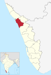
| Description | Location of Kozhikode district in Kerala |
| Date | (UTC) |
| Source | |
| Author |
|
I, the copyright holder of this work, hereby publish it under the following license:
This file is licensed under the Creative Commons Attribution-Share Alike 3.0 Unported license.
- You are free:
- to share – to copy, distribute and transmit the work
- to remix – to adapt the work
- Under the following conditions:
- attribution – You must give appropriate credit, provide a link to the license, and indicate if changes were made. You may do so in any reasonable manner, but not in any way that suggests the licensor endorses you or your use.
- share alike – If you remix, transform, or build upon the material, you must distribute your contributions under the same or compatible license as the original.
Original upload log
[edit]
This image is a derivative work of the following images:
- File:India_Kerala_location_map.svg licensed with Cc-by-sa-3.0
- 2011-03-11T09:30:07Z NordNordWest 827x1205 (135528 Bytes) =={{int:filedesc}}== {{Information |Description= {{de|Positionskarte von [[:de:Kerala|Kerala]], [[:de:Indien|Indien]]}} Quadratische Plattkarte, N-S-Streckung 102 %. Geographische Begrenzung der Karte: * N: 13.0° N * S: 8.0�
Uploaded with derivativeFX
File history
Click on a date/time to view the file as it appeared at that time.
| Date/Time | Thumbnail | Dimensions | User | Comment | |
|---|---|---|---|---|---|
| current | 16:52, 10 June 2023 | | 874 × 1,274 (539 KB) | C1MM (talk | contribs) | updated bounds |
| 06:36, 4 September 2021 |  | 775 × 1,129 (507 KB) | C1MM (talk | contribs) | c bounds | |
| 11:22, 3 April 2011 |  | 827 × 1,205 (73 KB) | BishkekRocks (talk | contribs) | fix | |
| 14:12, 11 March 2011 |  | 827 × 1,205 (83 KB) | BishkekRocks (talk | contribs) | {{Information |Description=Location of Kozhikode district in Kerala |Source=*File:India_Kerala_location_map.svg |Date=2011-03-11 14:09 (UTC) |Author=*File:India_Kerala_location_map.svg: {{U|NordNordWest}} *derivative work: ~~~ |Permission= |ot |
You cannot overwrite this file.
File usage on Commons
The following 6 pages use this file:
File usage on other wikis
The following other wikis use this file:
- Usage on ar.wikipedia.org
- Usage on arz.wikipedia.org
- Usage on bn.wikipedia.org
- Usage on ca.wikipedia.org
- Usage on ceb.wikipedia.org
- Usage on de.wikipedia.org
- Usage on en.wikipedia.org
- Usage on en.wiktionary.org
- Usage on es.wikipedia.org
- Usage on eu.wikipedia.org
- Usage on fa.wikipedia.org
- Usage on fr.wikipedia.org
- Usage on he.wikipedia.org
- Usage on hi.wikipedia.org
- Usage on it.wikipedia.org
- Usage on ko.wikipedia.org
- Usage on ml.wikipedia.org
- Usage on new.wikipedia.org
- Usage on nl.wikipedia.org
- Usage on no.wikipedia.org
- Usage on oc.wikipedia.org
- Usage on pt.wikipedia.org
- Usage on ru.wikipedia.org
- Usage on sa.wikipedia.org
- Usage on sv.wikipedia.org
- Usage on ta.wikipedia.org
- கோழிக்கோடு மாவட்டம்
- வார்ப்புரு:கோழிக்கோடு மாவட்டம்
- பாலுசேரி
- குற்றியாடி
- நாதாபுரம்
- கொயிலாண்டி
- பேராம்பிரா
- எலத்தூர், கோழிக்கோடு
- பேப்பூர்
- குந்தமங்கலம்
- திருவம்பாடி
- பேப்பூர் சட்டமன்றத் தொகுதி
- நரிப்பற்றா ஊராட்சி
- கொடுவள்ளி சட்டமன்றத் தொகுதி
- கொடுவள்ளி ஊராட்சி
- குந்தமங்கலம் ஊராட்சி
- குந்தமங்கலம் சட்டமன்றத் தொகுதி
- நாதாபுரம் சட்டமன்றத் தொகுதி
- மருதோங்கரை ஊராட்சி
- கோட்டூர் ஊராட்சி, கோழிக்கோடு
- தூணேரி ஊராட்சி
View more global usage of this file.