File:India - administrative map.png
Jump to navigation
Jump to search

Size of this preview: 514 × 600 pixels. Other resolutions: 206 × 240 pixels | 411 × 480 pixels | 658 × 768 pixels | 878 × 1,024 pixels | 1,487 × 1,735 pixels.
Original file (1,487 × 1,735 pixels, file size: 373 KB, MIME type: image/png)
Captions
Captions
Add a one-line explanation of what this file represents
| Description |
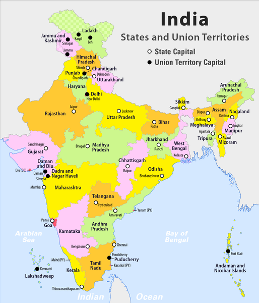
English: Administrative Map of India with States an Union Territories
Deutsch: Administrative Karte von Indien mit Bundesstaaten und Unionsterritorien |
| Date | see file history |
| Source | Own work |
| Author | Maximilian Dörrbecker (Chumwa) |
| Permission (Reusing this file) |
I, the copyright holder of this work, hereby publish it under the following license: This file is licensed under the Creative Commons Attribution-Share Alike 2.5 Generic license.
|
| Other versions |
|


File history
Click on a date/time to view the file as it appeared at that time.
| Date/Time | Thumbnail | Dimensions | User | Comment | |
|---|---|---|---|---|---|
| current | 22:39, 18 January 2020 | | 1,487 × 1,735 (373 KB) | Chumwa (talk | contribs) | + Ladakh |
| 20:50, 20 November 2016 |  | 1,487 × 1,735 (368 KB) | Chumwa (talk | contribs) | Amaravati with correct symbol and font | |
| 17:31, 6 June 2016 |  | 1,487 × 1,735 (393 KB) | RaviC (talk | contribs) | + Amaravati | |
| 20:27, 29 June 2014 |  | 1,487 × 1,735 (254 KB) | Kopiersperre (talk | contribs) | optipng | |
| 21:34, 27 June 2014 |  | 1,487 × 1,735 (368 KB) | Chumwa (talk | contribs) | {{Information |Description= {{en|Administrative Map of India with States an Union Territories}} {{de|Administrative Karte von Indien mit Bundesstaaten und Unionsterritorien}} |Source = {{own}} |Date = see file history |Author = [[:de:User:Chumwa|Maxi... |
You cannot overwrite this file.
File usage on Commons
The following 5 pages use this file:
File usage on other wikis
The following other wikis use this file:
- Usage on ar.wikipedia.org
- Usage on bh.wikipedia.org
- Usage on de.wikipedia.org
- Usage on en.wikipedia.org
- Category:Categories by state or union territory of India
- Category:Flora of India by state or union territory
- Template:Portal/doc/all
- Category:Environment of India by state or union territory
- Tourism in India by state
- Wikipedia:WikiProject India/Templates
- Wikipedia:Userboxes/WikiProjects/alphabetical/14
- Wikipedia:Userboxes/WikiProjects/Regional/05
- Talk:Bleed India with a Thousand Cuts
- Usage on en.wikibooks.org
- Usage on es.wikipedia.org
- Usage on hi.wikipedia.org
- Usage on incubator.wikimedia.org
- Usage on it.wikipedia.org
- Usage on ja.wikipedia.org
- Usage on mai.wikipedia.org
- Usage on ml.wikipedia.org
- Usage on my.wikipedia.org
- Usage on nl.wikipedia.org
- Usage on pa.wikipedia.org
- Usage on pl.wikipedia.org
- Usage on sat.wikipedia.org
- Usage on si.wikipedia.org
- Usage on ta.wikipedia.org
- Usage on ta.wikinews.org
- Usage on tum.wikipedia.org