File:Index map Series L792.jpg
Jump to navigation
Jump to search

Size of this preview: 410 × 599 pixels. Other resolutions: 164 × 240 pixels | 328 × 480 pixels | 526 × 768 pixels | 701 × 1,024 pixels | 2,200 × 3,214 pixels.
Original file (2,200 × 3,214 pixels, file size: 967 KB, MIME type: image/jpeg)
Captions
Captions
Add a one-line explanation of what this file represents
Summary
[edit]
| Description |
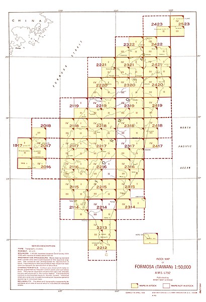
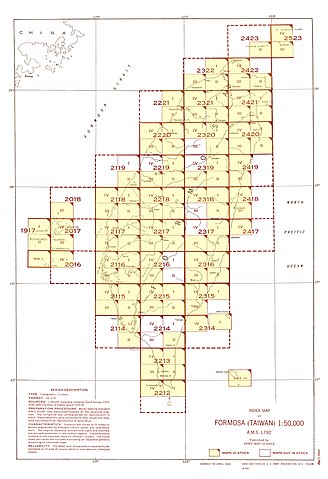
English: Index Map for AMS Series L792 (Note: Although in this index map map sheet 2214 I is not shown as a map in stock, the map was published in December 1944 and would have existed at the time this index map was created.) |
| Date | |
| Source | Courtesy of the University of Texas Libraries, The University of Texas at Austin. |
| Author | Army Map Serivce, Corps of Engineers |
Licensing
[edit]
This image or file is a work of a U.S. Army Corps of Engineers soldier or employee, taken or made as part of that person's official duties. As a work of the U.S. federal government, the image is in the public domain.
|
| Annotations | This image is annotated: View the annotations at Commons |
File history
Click on a date/time to view the file as it appeared at that time.
| Date/Time | Thumbnail | Dimensions | User | Comment | |
|---|---|---|---|---|---|
| current | 07:48, 20 October 2019 | | 2,200 × 3,214 (967 KB) | Geographyinitiative (talk | contribs) | User created page with UploadWizard |
You cannot overwrite this file.
File usage on Commons
The following 19 pages use this file:
- File:Txu-pclmaps-oclc-6550512-byobi-to-2212-iv.jpg
- File:Txu-pclmaps-oclc-6550512-gaian-1917-i.jpg
- File:Txu-pclmaps-oclc-6550512-garan-bi-2212-i.jpg
- File:Txu-pclmaps-oclc-6550512-hana-shima-1917-ii.jpg
- File:Txu-pclmaps-oclc-6550512-kitsubai-to-2018-iii.jpg
- File:Txu-pclmaps-oclc-6550512-kosei-to-2017-iii.jpg
- File:Txu-pclmaps-oclc-6550512-koshun-2213-iii.jpg
- File:Txu-pclmaps-oclc-6550512-koto-sho-2413-iii.jpg
- File:Txu-pclmaps-oclc-6550512-mako-2017-iv.jpg
- File:Txu-pclmaps-oclc-6550512-o-shima-1916-i.jpg
- File:Txu-pclmaps-oclc-6550512-shinka-2116-ii.jpg
- File:Txu-pclmaps-oclc-6550512-tansui-2322-i.jpg
- File:Txu-pclmaps-oclc-6550512-to-kichi-to-2016-iv.jpg
- File:Txu-pclmaps-oclc-6550514-hoka-sho-2523-iv.jpg
- File:Txu-pclmaps-oclc-6550514-kahei-sho-2423-ii.jpg
- File:Txu-pclmaps-oclc-6550514-menka-sho-2523-iii.jpg
- File:Txu-pclmaps-oclc-6550514-rato-2421-ii.jpg
- File:Txu-pclmaps-oclc-6550514-toi-2421-i.jpg
- Category:Formosa (Taiwan) 1:50,000 AMS Series L792