File:Index Map of Regions based on Admiralty Chart Catalogue 1967.jpg
Jump to navigation
Jump to search

Size of this preview: 800 × 566 pixels. Other resolutions: 320 × 226 pixels | 640 × 453 pixels | 1,024 × 724 pixels | 1,280 × 906 pixels | 2,560 × 1,811 pixels | 4,782 × 3,383 pixels.
Original file (4,782 × 3,383 pixels, file size: 1.12 MB, MIME type: image/jpeg)
Captions
Captions
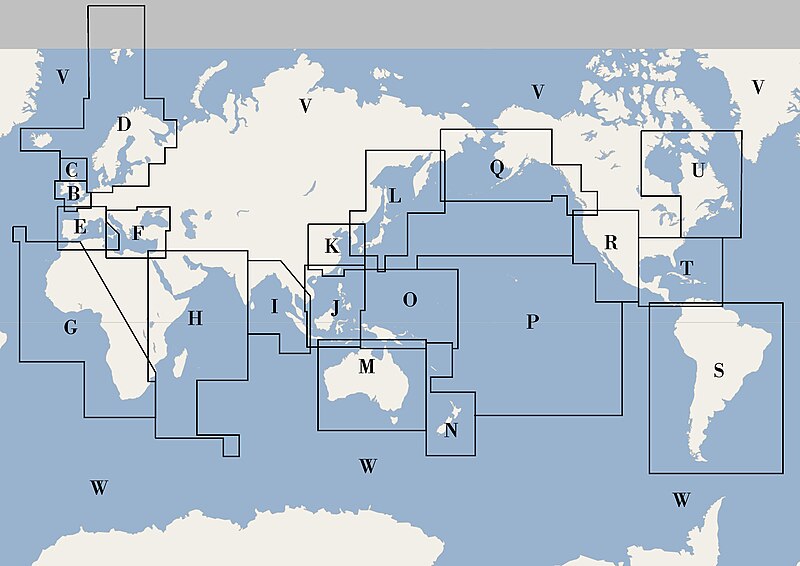
Index map of regions of the world
Summary
[edit]
| Description |
English: Index map of regions of the world used for classification of Admiralty charts in the 1967 Catalogue: (1967) Catalogue of Admiralty Charts and Hydrographic Publications. Complete world-wide edition, Hydrographer of the Navy . Re-drawn from the index map om page 11. |
| Date | |
| Source | Own work |
| Author | Kognos |
Licensing
[edit]
I, the copyright holder of this work, hereby publish it under the following license:
| This file is made available under the Creative Commons CC0 1.0 Universal Public Domain Dedication. | |
| The person who associated a work with this deed has dedicated the work to the public domain by waiving all of their rights to the work worldwide under copyright law, including all related and neighboring rights, to the extent allowed by law. You can copy, modify, distribute and perform the work, even for commercial purposes, all without asking permission.
|
File history
Click on a date/time to view the file as it appeared at that time.
| Date/Time | Thumbnail | Dimensions | User | Comment | |
|---|---|---|---|---|---|
| current | 22:01, 14 April 2024 | | 4,782 × 3,383 (1.12 MB) | Kognos (talk | contribs) | Uploaded own work with UploadWizard |
You cannot overwrite this file.
File usage on Commons
The following page uses this file: