File:Important environmental areas, lower Otter and Dead Creeks watershed, Addison County, Vermont LOC 81690345.jpg
Jump to navigation
Jump to search

Size of this preview: 800 × 429 pixels. Other resolutions: 320 × 172 pixels | 640 × 343 pixels | 1,024 × 549 pixels | 1,280 × 687 pixels | 2,560 × 1,373 pixels | 6,159 × 3,304 pixels.
Original file (6,159 × 3,304 pixels, file size: 2.27 MB, MIME type: image/jpeg)
Captions
Captions
Add a one-line explanation of what this file represents
Summary
[edit]| Description |
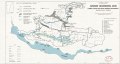
English: Shows wetlands, unique geologic areas, "biologic" areas, potential aquifer recharge areas, and fisheries. Oriented with north to the left. Includes index and location map. "1-16119." Available also through the Library of Congress Web site as a raster image. |
||
| Title | Important environmental areas, lower Otter and Dead Creeks watershed, Addison County, Vermont | ||
| Shelf ID | G3752.O87G3 1980 .U5 | ||
| Date | |||
| Source | https://www.loc.gov/item/81690345/ | ||
| Author | United States. Soil Conservation Service | ||
| Permission (Reusing this file) |
|
||
| Other versions |
|
||
| Location | United States · Vermont · Otter Creek Watershed · Dead Creek Watershed | ||
| Part of | American Memory · Catalog · Geography And Map Division · Additional Conservation And Environment Cartographic Items | ||
| Subject | Vermont · Nature Conservation · Natural Areas · Dead Creek Watershed · United States · Maps · Conservation Of Natural Resources · Otter Creek Watershed |

Licensing
[edit]
| This work is from the Library of Congress. According to the library, there are no known copyright restrictions on the use of this work. |  |
File history
Click on a date/time to view the file as it appeared at that time.
| Date/Time | Thumbnail | Dimensions | User | Comment | |
|---|---|---|---|---|---|
| current | 18:09, 11 June 2018 | | 6,159 × 3,304 (2.27 MB) | Fæ (talk | contribs) | LOC Maps https://www.loc.gov/item/81690345/ #12195 |
You cannot overwrite this file.
File usage on Commons
The following page uses this file: