File:Imagen satelite Lima.jpg

Original file (2,328 × 1,308 pixels, file size: 1.19 MB, MIME type: image/jpeg)
Captions
Captions
Summary
[edit]
| Description |
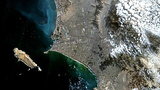
Português: Céu de brigadeiro atípico em Lima, Perú. Área à esq. da imagem, quase toda em preto é o Oceano Pacífico. A exceção são áreas esverdeadas e azul claras, próximas à costa, indicando alta produtividade primária (principalmente fitoplancton) / Clear skies at Lima, Peru. In black the Pacific Ocean, except some greenish and light blue areas, near the coast, indicating high primary productivity (mostly phytoplancton).
San Lourenzo, a maior ilha Peruana, aparece à esq. da imagem. Ilha deserta, sem fonte de água nem vegetação, daí sua cor amarronzada, nunca foi urbanizada / Largest Peruvian island, San Lorenzo, is at image lower left. A barren island, with no source of water and no vegetation, there why its brownish color, it has never been urbanized. O Centro de Lima está um pouco à dir. do da imagem. A grande mancha verde escuro ao seu Sul é o Campo do Clube de Golfe de Lima. Ao Sudeste está Miraflores, que com seus hotéis, restaurantes, bares, boates e lojas de departamento, é uma das principais atrações turísticas na cidade / Dowtown Lima is to the right of image center. A large green patch, to its South, is Lima Golf Club field. To the SE is Miraflores, which with its hotels, restaurants, bars, nightclubs and department stores, is one of the main tourist attractions in town. Imagem / Image: CBERS4 MUX Coordenadas do centro da imagem / Image center: 12°02'33.8"S 77°03'59.4"W Data / Date: 16-05-2018 / 2018-16-05 RGB 765 (cor verdadeira / true color) Cena / Scene: 189/113 Autor / Author: Oton Barros (DSR/OBT/INPE) Imagem em HD / HD Image Visite-nos / Visit us: www.dsr.inpe.br |
| Date | |
| Source | https://www.flickr.com/photos/observacao-da-terra/42208502392/ |
| Author | Coordenação-Geral de Observação da Terra/INPE |
Licensing
[edit]
- You are free:
- to share – to copy, distribute and transmit the work
- to remix – to adapt the work
- Under the following conditions:
- attribution – You must give appropriate credit, provide a link to the license, and indicate if changes were made. You may do so in any reasonable manner, but not in any way that suggests the licensor endorses you or your use.
- share alike – If you remix, transform, or build upon the material, you must distribute your contributions under the same or compatible license as the original.
| This image was originally posted to Flickr by Coordenação-Geral de Observação da Terra/INPE at https://flickr.com/photos/153282474@N02/42208502392 (archive). It was reviewed on 18 October 2019 by FlickreviewR 2 and was confirmed to be licensed under the terms of the cc-by-sa-2.0. |
File history
Click on a date/time to view the file as it appeared at that time.
| Date/Time | Thumbnail | Dimensions | User | Comment | |
|---|---|---|---|---|---|
| current | 14:46, 18 October 2019 | | 2,328 × 1,308 (1.19 MB) | MiguelAlanCS (talk | contribs) | User created page with UploadWizard |
You cannot overwrite this file.
File usage on Commons
The following 2 pages use this file:
.jpg&redirect=no)
File usage on other wikis
The following other wikis use this file:
- Usage on en.wikipedia.org