File:Ilha Grande topographic map.png
Jump to navigation
Jump to search

Size of this preview: 800 × 465 pixels. Other resolutions: 320 × 186 pixels | 640 × 372 pixels | 1,024 × 596 pixels | 1,280 × 745 pixels | 2,052 × 1,194 pixels.
Original file (2,052 × 1,194 pixels, file size: 1.52 MB, MIME type: image/png)
Captions
Captions
Add a one-line explanation of what this file represents
Summary
[edit]| Description |
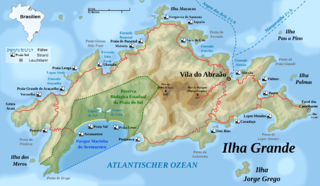
English: Detailed topographic map in German of Ilha Grande
Deutsch: Topografische Karte der Ilha Grande, deutsche Version
Français : Carte topographique détaillée en allemand de l'Ilha Grande
Português: Mapa topográfico detalhado em alemão de Ilha Grande |
| Date | |
| Source |
Own work by uploader, using: |
| Creator | |
| Georeferencing | If inappropriate please set warp_status = skip to hide. |
| Other versions |
|


.svg)

|
This map has been made or improved in the German Kartenwerkstatt (Map Lab). You can propose maps to improve as well.
|

|
This map image could be re-created using vector graphics as an SVG file. This has several advantages; see Commons:Media for cleanup for more information. If an SVG form of this image is available, please upload it and afterwards replace this template with
{{vector version available|new image name}}.
It is recommended to name the SVG file “Ilha Grande topographic map.svg”—then the template Vector version available (or Vva) does not need the new image name parameter. |
Licensing
[edit]
I, the copyright holder of this work, hereby publish it under the following licenses:
This file is licensed under the Creative Commons Attribution-Share Alike 3.0 Unported license.
- You are free:
- to share – to copy, distribute and transmit the work
- to remix – to adapt the work
- Under the following conditions:
- attribution – You must give appropriate credit, provide a link to the license, and indicate if changes were made. You may do so in any reasonable manner, but not in any way that suggests the licensor endorses you or your use.
- share alike – If you remix, transform, or build upon the material, you must distribute your contributions under the same or compatible license as the original.

|
Permission is granted to copy, distribute and/or modify this document under the terms of the GNU Free Documentation License, Version 1.2 or any later version published by the Free Software Foundation; with no Invariant Sections, no Front-Cover Texts, and no Back-Cover Texts. A copy of the license is included in the section entitled GNU Free Documentation License. |
You may select the license of your choice.
File history
Click on a date/time to view the file as it appeared at that time.
| Date/Time | Thumbnail | Dimensions | User | Comment | |
|---|---|---|---|---|---|
| current | 08:10, 5 July 2009 | | 2,052 × 1,194 (1.52 MB) | Rosso Robot (talk | contribs) | discription change |
| 09:29, 4 July 2009 |  | 2,052 × 1,194 (1.52 MB) | Rosso Robot (talk | contribs) | + thematic changes | |
| 14:51, 1 July 2009 |  | 2,052 × 1,194 (1.46 MB) | Rosso Robot (talk | contribs) | marginal correction | |
| 14:47, 1 July 2009 |  | 2,052 × 1,194 (1.46 MB) | Rosso Robot (talk | contribs) | marginal caption edit | |
| 14:29, 1 July 2009 |  | 2,052 × 1,194 (1.46 MB) | Rosso Robot (talk | contribs) | a few artwork corrections | |
| 14:08, 30 June 2009 |  | 2,052 × 1,194 (1.48 MB) | Rosso Robot (talk | contribs) | changed a lot | |
| 07:20, 30 June 2009 |  | 2,040 × 1,490 (1.49 MB) | Rosso Robot (talk | contribs) | {{Information |Description={{en|1=Detailed topographic map in German of Ilha Grande}} {{de|1=Topografische Karte der Ilha Grande, deutsche Version}} {{fr|1=Carte topographique détaillée en allemand de l'[[:fr:Ilha |
You cannot overwrite this file.
File usage on Commons
The following 4 pages use this file:
File usage on other wikis
The following other wikis use this file: