File:Ile Perrot 1817.png
Ile_Perrot_1817.png (600 × 466 pixels, file size: 97 KB, MIME type: image/png)
Captions
Captions
Summary
[edit]
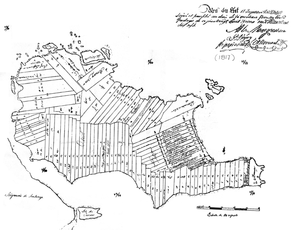
| Description | Carte de la seigneurie de l'Île-Perrot au moment du partage en 1817. Cette mappe est annexée à l'acte de Doucet du 28 mars 1817. Le lecteur doit remarquer que certaines îles, qui faisaient partie de la seigneurie quand Talon la concéda à Perrot, n'y figurent pas. D'abord l'Ile Saint-Gilles, (aujourd'hui Girwood island), qui se trouve tout près du fief Senneville et qui fut annexée à ce dernier fief (en raison de sa proximité) vers 1705‑6. Les Iles De La Paix également n'apparaissent pas sur la mappe puisque comme nous l'avons vu, elles n'étaient pas inclues dans la vente de la seigneurie par LeMoyne à Desruisseaux en 1703. Les Iles De La Paix furent vendues avec la seigneurie de Châteauguay par les mêmes LeMoyne |
| Date | |
| Source | [1] - [2] |
| Author | Anonymous |
![[2]](http://images.banq.qc.ca/BANQ/03Q/E21/S555SS3/SSS4/03Q_E21S555SS3SSS4P042.jpg)
Licensing
[edit]
|
This work is in the public domain in its country of origin and other countries and areas where the copyright term is the author's life plus 70 years or fewer.
| |
| This file has been identified as being free of known restrictions under copyright law, including all related and neighboring rights. | |
File history
Click on a date/time to view the file as it appeared at that time.
| Date/Time | Thumbnail | Dimensions | User | Comment | |
|---|---|---|---|---|---|
| current | 19:29, 29 December 2012 | | 600 × 466 (97 KB) | Jeangagnon (talk | contribs) | {{Information |Description=Carte de l'Île Perrot |Source=[http://www.icomos.org/~fleblanc/projects/1971-1979_PC/p_pc_moulin_ile_perrot_report.html] |Date=1817 |Author=Anonyme |Permission= |other_versions= }} Category:Île Perrot [[Category:1817 i... |
You cannot overwrite this file.
File usage on Commons
There are no pages that use this file.
File usage on other wikis
The following other wikis use this file:
- Usage on fr.wikipedia.org