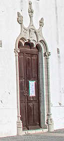
File:Igreja de Nossa Senhora da Graça - Palhais - Portugal (51116509065).jpg

Original file (5,118 × 3,412 pixels, file size: 13.25 MB, MIME type: image/jpeg)
Captions
Captions
Summary
[edit]| DescriptionIgreja de Nossa Senhora da Graça - Palhais - Portugal (51116509065).jpg |
O atual templo de Nª Sª da Graça resulta de sucessivas intervenções efetuadas desde que a pequena Ermida desta invocação foi erigida pela população local, provavelmente, em meados de quatrocentos. A Igreja, de traça quinhentista, apresenta-se como um dos raros monumentos da arquitetura manuelina no concelho. De nave única, o edifício apresenta duas Capelas funerárias laterais, de planta quadrada, com abóbadas de nervuras tão ao gosto quinhentista e desta época conserva ainda alguns painéis de azulejos enxaquetados, brancos e verdes. A decoração exterior da fachada principal apresenta um programa decorativo definido pelo portal axial em pedraria, cujo arco trilobado arranca de finas colunas de bases e capitéis lavrados, ornados por elementos vegetalistas e coroados por cogulhos dispostos em triângulo. A vivência ao nível local de uma elite de altos funcionários da Coroa relacionados com a Real Fábrica do Biscoito em Vale de Zebro, que decisivamente deixou marcas da sua existência na velha Ermida, foi determinante para a importância que a freguesia viria a assumir no contexto da Expansão Portuguesa. A Igreja de Nª Sª da Graça foi classificada como Monumento Nacional em 1922. <a href="https://www.cm-barreiro.pt/conhecer/patrimonio-historico-cultural-e-equipamentos/patrimonio-religioso/igreja-de-nossa-senhora-da-graca-de-palhais" rel="noreferrer nofollow">www.cm-barreiro.pt/conhecer/patrimonio-historico-cultural...</a> |
|||
| Date | ||||
| Source | Igreja de Nossa Senhora da Graça - Palhais - Portugal 🇵🇹 | |||
| Author | Vitor Oliveira from Torres Vedras, PORTUGAL | |||
| Other versions |
|
| Camera location | 38° 37′ 34.63″ N, 9° 02′ 58.21″ W | View this and other nearby images on: OpenStreetMap |
|---|
Licensing
[edit]- You are free:
- to share – to copy, distribute and transmit the work
- to remix – to adapt the work
- Under the following conditions:
- attribution – You must give appropriate credit, provide a link to the license, and indicate if changes were made. You may do so in any reasonable manner, but not in any way that suggests the licensor endorses you or your use.
- share alike – If you remix, transform, or build upon the material, you must distribute your contributions under the same or compatible license as the original.
| This image was originally posted to Flickr by Portuguese_eyes at https://flickr.com/photos/21446942@N00/51116509065. It was reviewed on 27 April 2021 by FlickreviewR 2 and was confirmed to be licensed under the terms of the cc-by-sa-2.0. |
27 April 2021
File history
Click on a date/time to view the file as it appeared at that time.
| Date/Time | Thumbnail | Dimensions | User | Comment | |
|---|---|---|---|---|---|
| current | 02:11, 27 April 2021 |  | 5,118 × 3,412 (13.25 MB) | Tm (talk | contribs) | Transferred from Flickr via #flickr2commons |
You cannot overwrite this file.
File usage on Commons
The following 2 pages use this file:
File usage on other wikis
The following other wikis use this file:
- Usage on es.wikipedia.org
- Usage on pt.wikipedia.org
- Usage on www.wikidata.org
Metadata
This file contains additional information such as Exif metadata which may have been added by the digital camera, scanner, or software program used to create or digitize it. If the file has been modified from its original state, some details such as the timestamp may not fully reflect those of the original file. The timestamp is only as accurate as the clock in the camera, and it may be completely wrong.
| Camera manufacturer | Canon |
|---|---|
| Camera model | Canon EOS Kiss X6i |
| Exposure time | 1/250 sec (0.004) |
| F-number | f/11 |
| ISO speed rating | 100 |
| Date and time of data generation | 17:34, 21 March 2021 |
| Lens focal length | 17 mm |
| Width | 5,118 px |
| Height | 3,412 px |
| Bits per component |
|
| Pixel composition | RGB |
| Orientation | Normal |
| Number of components | 3 |
| Horizontal resolution | 240 dpi |
| Vertical resolution | 240 dpi |
| Software used | Adobe Photoshop 22.3 (Macintosh) |
| File change date and time | 10:23, 1 April 2021 |
| Y and C positioning | Co-sited |
| Exposure Program | Normal program |
| Exif version | 2.31 |
| Date and time of digitizing | 17:34, 21 March 2021 |
| APEX shutter speed | 7.965784 |
| APEX aperture | 6.918863 |
| APEX exposure bias | 0 |
| Metering mode | Pattern |
| Flash | Flash did not fire, compulsory flash suppression |
| Supported Flashpix version | 1 |
| Color space | sRGB |
| Focal plane X resolution | 5,798.6577181208 |
| Focal plane Y resolution | 5,788.9447236181 |
| Focal plane resolution unit | inches |
| Custom image processing | Normal process |
| Exposure mode | Auto exposure |
| White balance | Auto white balance |
| Scene capture type | Standard |
| GPS tag version | 0.0.3.2 |
| Serial number of camera | 033031000929 |
| Lens used | EF-S17-85mm f/4-5.6 IS USM |
| Date metadata was last modified | 11:23, 1 April 2021 |
| Unique ID of original document | xmp.did:6C0190DAC68DEB118D0FD212CAF95F93 |
| IIM version | 4 |
