File:Igreja Matriz Carlópolis 060310 REFON 4 PANO.jpg
Jump to navigation
Jump to search

Size of this preview: 556 × 599 pixels. Other resolutions: 223 × 240 pixels | 445 × 480 pixels | 713 × 768 pixels | 1,033 × 1,113 pixels.
Original file (1,033 × 1,113 pixels, file size: 384 KB, MIME type: image/jpeg)
Captions
Captions
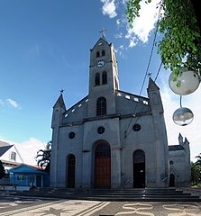
Mother Church of Carlopolis
Summary
[edit]
| Description |
Português: Vistas de Carlópolis, município brasileiro do estado do Paraná. |
| Date | |
| Source | Own work |
| Author | José Reynaldo da Fonseca |

|
NOTE: This image is a panorama consisting of multiple frames that were merged or stitched in software. As a result, this image necessarily underwent some form of digital manipulation. These manipulations may include blending, blurring, cloning, and colour and perspective adjustments. As a result of these adjustments, the image content may be slightly different from reality at the points where multiple images were combined. This manipulation is often required due to lens, perspective, and parallax distortions.
|
| Camera location | | View this and other nearby images on: OpenStreetMap |
|---|
Licensing
[edit]
I, the copyright holder of this work, hereby publish it under the following license:
This file is licensed under the Creative Commons Attribution-Share Alike 3.0 Unported license.
- You are free:
- to share – to copy, distribute and transmit the work
- to remix – to adapt the work
- Under the following conditions:
- attribution – You must give appropriate credit, provide a link to the license, and indicate if changes were made. You may do so in any reasonable manner, but not in any way that suggests the licensor endorses you or your use.
- share alike – If you remix, transform, or build upon the material, you must distribute your contributions under the same or compatible license as the original.
File history
Click on a date/time to view the file as it appeared at that time.
| Date/Time | Thumbnail | Dimensions | User | Comment | |
|---|---|---|---|---|---|
| current | 18:05, 3 May 2013 | | 1,033 × 1,113 (384 KB) | Reynaldo (talk | contribs) | User created page with UploadWizard |
You cannot overwrite this file.
File usage on Commons
The following page uses this file:
File usage on other wikis
The following other wikis use this file:
- Usage on ceb.wikipedia.org
- Usage on ce.wikipedia.org
- Usage on de.wikipedia.org
- Usage on en.wikipedia.org
- Usage on eo.wikipedia.org
- Usage on eu.wikipedia.org
- Usage on fr.wikipedia.org
- Usage on it.wikipedia.org
- Usage on ka.wikipedia.org
- Usage on mg.wikipedia.org
- Usage on no.wikipedia.org
- Usage on pl.wikipedia.org
- Usage on pt.wikipedia.org
- Usage on ro.wikipedia.org
- Usage on ru.wikipedia.org
- Usage on tt.wikipedia.org
- Usage on vi.wikipedia.org
- Usage on www.wikidata.org