File:Igl Compass Panorama.jpg
Jump to navigation
Jump to search

Size of this preview: 800 × 180 pixels. Other resolutions: 320 × 72 pixels | 640 × 144 pixels | 1,024 × 230 pixels | 1,280 × 288 pixels | 2,560 × 575 pixels | 27,527 × 6,186 pixels.
Original file (27,527 × 6,186 pixels, file size: 48.15 MB, MIME type: image/jpeg)
Captions
Captions
Add a one-line explanation of what this file represents
| Warning | The original file is very high-resolution. It might not load properly or could cause your browser to freeze when opened at full size. |
|---|
Summary
[edit]| Description |
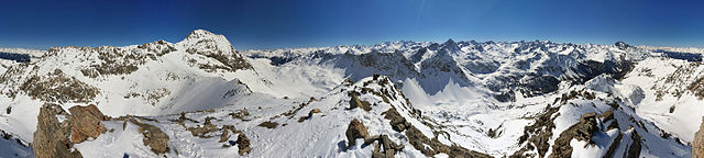
English: 360° panorama from Igl Compass (Bergün/Bravuogn and La Punt Chamues-ch, Grison, Switzerland)
Deutsch: 360°-Panorama vom Igl Compass (Bergün und La Punt-Chamues-ch, Graubünden, Schweiz)
Rumantsch: Vista panoramica da 360° d'Igl Compass (Bravuogn e La Punt-Chamues-ch, Grischun, Svizra)
Italiano: Vista panoramica di 360° da Igl Compass (Bergün/Bravuogn e La Punt Chamues-ch, Grigioni, Svizzera) |
||
| Date | |||
| Source |
Own work
|
||
| Author | Capricorn4049 | ||
| Permission (Reusing this file) |
|

| Camera location | | View this and other nearby images on: OpenStreetMap |
|---|
| 360° | View in 360° panoramic viewer
|
|---|
| Warning | The original file is very high-resolution. It might not load properly or could cause your browser to freeze when opened at full size. |
|---|
|
|
Further panoramas can be found here. |
Licensing
[edit]
This file is licensed under the Creative Commons Attribution-Share Alike 4.0 International license.
- You are free:
- to share – to copy, distribute and transmit the work
- to remix – to adapt the work
- Under the following conditions:
- attribution – You must give appropriate credit, provide a link to the license, and indicate if changes were made. You may do so in any reasonable manner, but not in any way that suggests the licensor endorses you or your use.
- share alike – If you remix, transform, or build upon the material, you must distribute your contributions under the same or compatible license as the original.
| Annotations | This image is annotated: View the annotations at Commons |
File history
Click on a date/time to view the file as it appeared at that time.
| Date/Time | Thumbnail | Dimensions | User | Comment | |
|---|---|---|---|---|---|
| current | 20:44, 19 March 2016 | 27,527 × 6,186 (48.15 MB) | Capricorn4049 (talk | contribs) |
You cannot overwrite this file.
File usage on Commons
The following 4 pages use this file:
File usage on other wikis
The following other wikis use this file:
- Usage on de.wikipedia.org
- Usage on www.wikidata.org