File:Ierusalem (FL6881000 2368229).jpg
Jump to navigation
Jump to search

Size of this preview: 800 × 569 pixels. Other resolutions: 320 × 228 pixels | 640 × 455 pixels | 1,024 × 728 pixels | 1,280 × 910 pixels | 2,560 × 1,821 pixels | 2,950 × 2,098 pixels.
Original file (2,950 × 2,098 pixels, file size: 4.02 MB, MIME type: image/jpeg)
Captions
Captions
Add a one-line explanation of what this file represents
Summary
[edit]| Ierusalem
( |
||||||||||||||||||||||||
|---|---|---|---|---|---|---|---|---|---|---|---|---|---|---|---|---|---|---|---|---|---|---|---|---|
| Artist |
| |||||||||||||||||||||||
| Contributors | Adrichem, Christiaan van, 1533-1585 | |||||||||||||||||||||||
| Title |
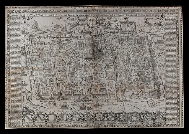
Ierusalem |
|||||||||||||||||||||||
| Description |
Ierusalem. described as it stoode in greatest beautie the cheife places & Actions obserued with a chronology from the first Erection to the last Ruins.. |
|||||||||||||||||||||||
| Language | English | |||||||||||||||||||||||
| Publication date | 16th century | |||||||||||||||||||||||
| Medium | Two sheets pasted together ; | |||||||||||||||||||||||
| Dimensions | height: 553 mm (21.77 in); width: 810 mm (31.88 in) | |||||||||||||||||||||||
| Collection |
|
|||||||||||||||||||||||
| Current location |
|
|||||||||||||||||||||||
| Place of publication | unknown | |||||||||||||||||||||||
| search Merhav catalog | unknown | |||||||||||||||||||||||
| Notes | Copperplate; An imaginary plan; Drawn after Adrichom, at the beginning of the 17th century; A similar map was engraved in 1625 by Benjamin Wright, (1575/6-). See article by Louis van Empelen. | |||||||||||||||||||||||
| IE PID | IE6880994 | |||||||||||||||||||||||
| Rosetta filename | FL6881000 | |||||||||||||||||||||||
| NNL item ID (P3959) | 990023682290205171 | |||||||||||||||||||||||
| search Merhav catalog | English | |||||||||||||||||||||||
| Source/Photographer |
|
|||||||||||||||||||||||
| Other versions | ||||||||||||||||||||||||
| Jpg / Tif version |
|
|||||||||||||||||||||||

.jpg)

.jpg&action=edit§ion=1)
Licensing
[edit].jpg&action=edit§ion=2)
The copyright situation of this work is theoretically uncertain, because in the country of origin copyright lasts 70 years after the death of the author, and the date of the author's death is unknown. However, the date of creation of the work was over 120 years ago, and it is thus a reasonable assumption that the copyright has expired (see here for the community discussion). Do not use this template if the date of death of the author is known.
| |
| This file has been identified as being free of known restrictions under copyright law, including all related and neighboring rights. | |
File history
Click on a date/time to view the file as it appeared at that time.
| Date/Time | Thumbnail | Dimensions | User | Comment | |
|---|---|---|---|---|---|
| current | 01:47, 28 July 2023 | | 2,950 × 2,098 (4.02 MB) | Geagea (talk | contribs) | pattypan 22.03 |
You cannot overwrite this file.
File usage on Commons
The following page uses this file:
.jpg&oldid=787456066)