File:Ice on the Great Lakes (MODIS 2021-02-05).jpg
Original file (1,769 × 1,425 pixels, file size: 287 KB, MIME type: image/jpeg)
Captions
Captions
Summary
[edit].jpg&action=edit§ion=1)
| Description |
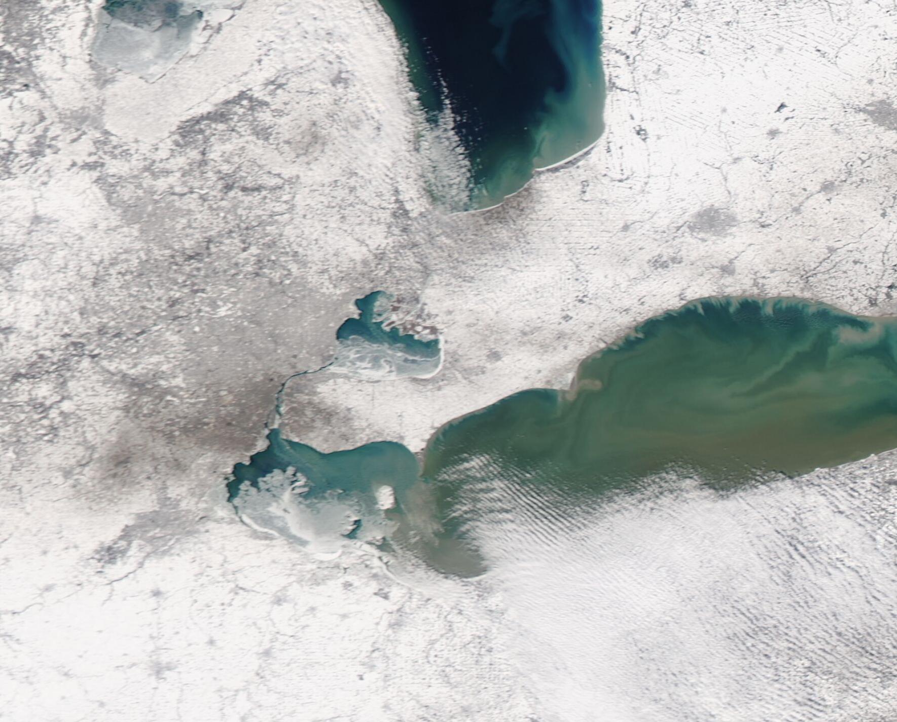
English: After recording the second-lowest ice cover across the Great Lakes in January, a frigid cold snap at the close of the month brought increasing ice by early February 2021. The average ice cover for the Great Lakes in January 2021 was reported at just 4.4%, which comes close to the record low set for the month in 2002, when only 4.08% of the lakes were under ice. After a week-long cold snap, however, the National Weather Service reported total ice coverage of 11.5% as of February 3. The National Oceanic and Atmospheric Administration’s Great Lakes Environmental Research Lab (NOAA GLERL) has forecast that the maximum ice coverage for the 2020-2021 winter will peak at about 30 percent—substantially lower than the average of 53 percent.
Although ice may be scarce over much of the region, in some areas where it exists-such as Lake St. Clair—it has proven impactful. Located between Lake Erie to the south and Lake Huron (north), shallow Lake St. Clair has an average depth of just 11 feet (3.4 meters). It freezes more quickly than the deeper Great Lakes and by February 3 was about 90 percent ice-covered. Water from Lake Huron flows into Lake St. Clair through the St. Clair River—except when the flow is impeded by ice jams. As ice coverage increased over the northern portion of the lake as well as on the river, winds blew northward. This pushed lake ice into the south-flowing river ice, creating a large ice jam. Since ice jams basically act like dams and obstruct river flow, long-lasting ice jams can cause significant flooding. Rising waters have caused flooding from Algonac to Port Huron since February 1. US Coast Guard and Canadian ice breaking ships have been working to bring relief by crumbing ice jams and restoring the flow of water into Lake St. Clair. The Moderate Resolution Imaging Spectroradiometer (MODIS) on board NASA’s Aqua satellite acquired a true-color image of ice across parts of the Great Lakes on February 3. Lake St. Clair sits in the center of the image, with Lake Huron to the north and Lake Erie in the south. Saginaw Bay, the southern tip of Lake Michigan, can be seen in the northwest. The floodwaters of the St. Clair River are largely obscured by cloud cover. |
||
| Date | Taken on 3 February 2021 | ||
| Source |
Ice on the Great Lakes (direct link)
|
||
| Author | MODIS Land Rapid Response Team, NASA GSFC |
| This media is a product of the Aqua mission Credit and attribution belongs to the mission team, if not already specified in the "author" row |
Licensing
[edit].jpg&action=edit§ion=2)
| This file is in the public domain in the United States because it was solely created by NASA. NASA copyright policy states that "NASA material is not protected by copyright unless noted". (See Template:PD-USGov, NASA copyright policy page or JPL Image Use Policy.) | ||
 |
Warnings:
|
File history
Click on a date/time to view the file as it appeared at that time.
| Date/Time | Thumbnail | Dimensions | User | Comment | |
|---|---|---|---|---|---|
| current | 18:03, 30 January 2024 | | 1,769 × 1,425 (287 KB) | OptimusPrimeBot (talk | contribs) | #Spacemedia - Upload of http://modis.gsfc.nasa.gov/gallery/images/image02052021_250m.jpg via Commons:Spacemedia |
You cannot overwrite this file.
File usage on Commons
There are no pages that use this file.
.jpg&oldid=847257654)