File:ISS-Karakoram.JPG
Jump to navigation
Jump to search

Size of this preview: 800 × 528 pixels. Other resolutions: 320 × 211 pixels | 640 × 422 pixels | 1,024 × 676 pixels | 1,280 × 844 pixels | 2,992 × 1,974 pixels.
Original file (2,992 × 1,974 pixels, file size: 2.82 MB, MIME type: image/jpeg)
Captions
Captions
Add a one-line explanation of what this file represents
Summary
[edit]
| Description |
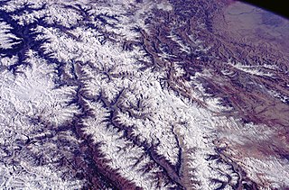
English: The Karakoram-Range seen from the International Space Station (ISS).
Deutsch: Das Karakorum-Gebirge von der Internationalen Raumstation (ISS) aus gesehen |
| Date | |
| Source | http://eol.jsc.nasa.gov/scripts/sseop/photo.pl?mission=ISS001&roll=343&frame=30 |
| Author | Nasa |
| Camera location | | View this and other nearby images on: OpenStreetMap |
|---|
This image or video was catalogued by one of the centers of the United States National Aeronautics and Space Administration (NASA) under Photo ID: ISS001-343-30. This tag does not indicate the copyright status of the attached work. A normal copyright tag is still required. See Commons:Licensing. Other languages:
|
Licensing
[edit]
| This file is in the public domain in the United States because it was solely created by NASA. NASA copyright policy states that "NASA material is not protected by copyright unless noted". (See Template:PD-USGov, NASA copyright policy page or JPL Image Use Policy.) | ||
 |
Warnings:
|
| Annotations | This image is annotated: View the annotations at Commons |
File history
Click on a date/time to view the file as it appeared at that time.
| Date/Time | Thumbnail | Dimensions | User | Comment | |
|---|---|---|---|---|---|
| current | 14:12, 18 March 2016 | | 2,992 × 1,974 (2.82 MB) | Ras67 (talk | contribs) | cropped and leveled from NASA's uncompressed TIFF |
| 16:10, 4 November 2009 |  | 3,070 × 2,044 (851 KB) | Rupert Pupkin (talk | contribs) | brightness and contrast adjusted | |
| 13:41, 7 January 2009 |  | 3,070 × 2,044 (795 KB) | Rupert Pupkin (talk | contribs) | {{Information |Description={{en|1=The Karakoram-Range seen from the International Space Station (ISS).}} {{de|1=Das Karakorum-Gebirge von der Internationalen Raumstation (ISS) aus gesehen}} |Source=http://eol.jsc.nasa.gov/scripts/sseop/photo.pl?mission=IS |
You cannot overwrite this file.
File usage on Commons
The following 2 pages use this file:
File usage on other wikis
The following other wikis use this file:
- Usage on bn.wikipedia.org
- Usage on es.wikipedia.org
- Usage on fr.wikipedia.org
- Usage on ig.wikipedia.org
- Usage on ko.wikipedia.org
- Usage on ky.wikipedia.org
- Usage on pl.wikipedia.org
- Usage on ru.wikipedia.org
- Usage on ug.wikipedia.org
- Usage on uk.wikipedia.org
- Usage on www.wikidata.org