File:ISS-39 Galveston Island.jpg
Jump to navigation
Jump to search

Size of this preview: 800 × 532 pixels. Other resolutions: 320 × 213 pixels | 640 × 426 pixels | 1,024 × 681 pixels | 1,280 × 852 pixels | 2,560 × 1,703 pixels | 4,256 × 2,832 pixels.
Original file (4,256 × 2,832 pixels, file size: 2.78 MB, MIME type: image/jpeg)
Captions
Captions
Add a one-line explanation of what this file represents
Summary
[edit]
| Description |
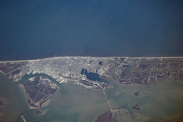
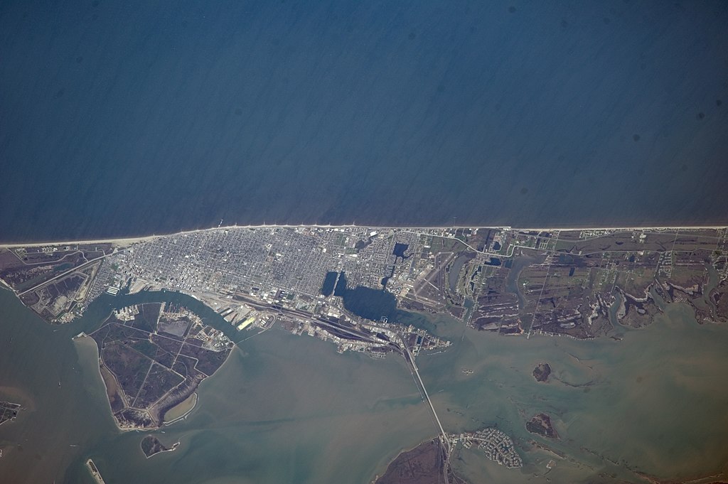
English: This nadir picture of Galveston Island and its coastline on the Gulf of Mexico was taken by one of the Expedition 39 crew members aboard the International Space Station on March 12.
|
| Date | |
| Source | https://www.flickr.com/photos/nasa2explore/13134466323/ |
| Author | NASA |
This image or video was catalogued by Johnson Space Center of the United States National Aeronautics and Space Administration (NASA) under Photo ID: ISS039-E-000707. This tag does not indicate the copyright status of the attached work. A normal copyright tag is still required. See Commons:Licensing. Other languages:
|
Licensing
[edit]
This file is in the public domain in the United States because it was created by the Image Science & Analysis Laboratory, of the NASA Johnson Space Center. NASA copyright policy states that "NASA material is not protected by copyright unless noted". (NASA media use guidelines or Conditions of Use of Astronaut Photographs).
Photo source: ISS039-E-000707.
|
File history
Click on a date/time to view the file as it appeared at that time.
| Date/Time | Thumbnail | Dimensions | User | Comment | |
|---|---|---|---|---|---|
| current | 21:50, 29 June 2014 | | 4,256 × 2,832 (2.78 MB) | Ras67 (talk | contribs) | high quality rendering from NASA' raw data |
| 16:05, 27 June 2014 |  | 4,256 × 2,832 (820 KB) | Ras67 (talk | contribs) | == {{int:filedesc}} == {{Information |Description={{en|1=This nadir picture of Galveston Island and its coastline on the Gulf of Mexico was taken by one of the Expedition 39 crew members aboard the International Space Station on March 12. It was among... |
You cannot overwrite this file.
File usage on Commons
The following 2 pages use this file:
File usage on other wikis
The following other wikis use this file:
- Usage on arz.wikipedia.org
- Usage on be.wikipedia.org
- Usage on ceb.wikipedia.org
- Usage on es.wikipedia.org
- Usage on et.wikipedia.org
- Usage on eu.wikipedia.org
- Usage on fi.wikipedia.org
- Usage on it.wikipedia.org
- Usage on ru.wikipedia.org
- Usage on sr.wikipedia.org
- Usage on www.wikidata.org