File:IN-7th.png
Jump to navigation
Jump to search
No higher resolution available.
IN-7th.png (635 × 380 pixels, file size: 56 KB, MIME type: image/png)
Captions
Captions
Add a one-line explanation of what this file represents
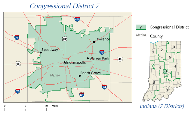
A map of United States House of Representatives, Indiana District 7.
The map is from nationalatlas.gov, specifically IN07_109.gif.
This map was obtained from an edition of the National Atlas of the United States. Like almost all works of the U.S. federal government, works from the National Atlas are in the public domain in the United States.
Online access: NationalAtlas.gov | 1970 print edition: Library of Congress, Perry-Castañeda Library
|

|
Textual information (e.g. timestamp) once visible in the image itself has been moved into the image metadata and/or image description page. This makes the image easier to reuse and more language-neutral, and makes the text easier to process and search for. Commons discourages placing visible textual information in images. All licenses accepted on Commons permit this type of modification as a derivative work.
If attribution information were removed and the image is not public domain, replace this tag with {{Attribution metadata from licensed image}}.
|
File history
Click on a date/time to view the file as it appeared at that time.
| Date/Time | Thumbnail | Dimensions | User | Comment | |
|---|---|---|---|---|---|
| current | 04:41, 3 August 2008 | | 635 × 380 (56 KB) | Jarekt (talk | contribs) | {{Information |Description=removed watermark |Source= |Date= |Author= |Permission= |other_versions= }} |
| 22:05, 11 April 2008 |  | 635 × 380 (40 KB) | TheHoosierState89 (talk | contribs) | A map of United States House of Representatives, Indiana District 7. The map is from [http://nationalatlas.gov/printable/congress.html#in nationalatlas.gov], specifically [http://nationalat |
You cannot overwrite this file.
File usage on Commons
There are no pages that use this file.
File usage on other wikis
The following other wikis use this file:
- Usage on en.wikipedia.org
- Usage on fr.wikipedia.org