File:ILmap.png
Jump to navigation
Jump to search
No higher resolution available.
ILmap.png (276 × 598 pixels, file size: 87 KB, MIME type: image/png)
Captions
Captions
Add a one-line explanation of what this file represents
Summary
[edit]
| Description |
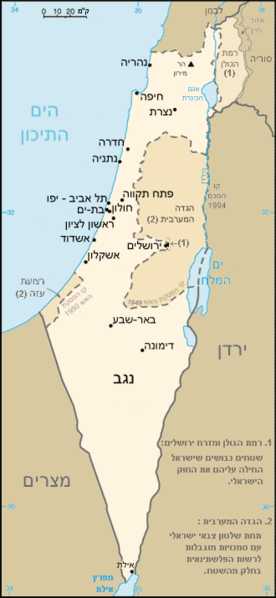
English: Map of Israel in hebrew, based on a map from the CIA world factbook
Français : Carte d'Israël en hébreu, basée sur une carte du CIA World Factbook, indiquant les principales villes du pays.
עברית: מפת ישראל בעברית |
| Source | Originally from he.wikipedia; description page is/was here. |
| Author |
The original uploader was Rgranit at Hebrew Wikipedia. Later versions were uploaded by דוד שי, Eman, נריה הרואה, Green Ape, ערן, אביעד, צהוב עולה at he.wikipedia. |
Licensing
[edit]
This image is in the public domain because it contains materials that originally came from the United States Central Intelligence Agency's World Factbook.
|
 |
Original upload log
[edit]
(All user names refer to he.wikipedia)
- 2007-03-04 13:55 אביעד 330×715×8 (23748 bytes) הורדת ההערה על רצועת עזה כבשלטון צבאי.
- 2006-11-06 13:35 צהוב עולה 330×715×8 (20629 bytes) לא לרמתה של ויקיפדיה לשים קרדיט על תמונות + זה PD אז כל אחד יכול להוריד את הקרדיט
- 2006-06-01 13:02 Eman 330×715×8 (26886 bytes) שוחזר לגרסה קודמת
- 2006-03-30 14:14 אביעד 330×715×8 (26768 bytes) שינוי עקב עדכון מידע
- 2005-09-15 14:32 ערן 330×715×8 (26886 bytes) שוחזר לגירסה קודמת
- 2005-09-15 03:36 Green Ape 330×715×8 (23084 bytes) מפת ישראל בעברית
- 2005-02-08 10:58 Eman 330×715×8 (26886 bytes) שוחזר לגירסה קודמת
- 2005-02-08 06:21 נריה הרואה 330×715×8 (26393 bytes) מפת ישראל מתוקנת
- 2005-02-05 13:27 Eman 330×715×8 (26886 bytes) גרסה חדשה עם הבחנה בין הגדה והרצועה לגולן ומזרח ירושלים + מפרץ עקבה -> מפרץ אילת (Jerusalem)
- 2005-02-05 12:23 Eman 330×715×8 (26273 bytes) שוחזר לגירסה קודמת
- 2005-02-05 01:08 נריה הרואה 330×715×8 (25536 bytes)
- 2005-02-04 14:00 Eman 330×715×8 (26273 bytes) שינוי צבע השטחים, ומחיקת הערה לא מדוייקת
- 2004-04-10 19:24 דוד שי 330×715×8 (27563 bytes) מפת ישראל - תיקון שגיאת כתיב
- 2004-02-13 14:44 Rgranit 330×715×8 (28761 bytes) מפת ישראל בעברית
File history
Click on a date/time to view the file as it appeared at that time.
| Date/Time | Thumbnail | Dimensions | User | Comment | |
|---|---|---|---|---|---|
| current | 03:18, 15 June 2007 | | 276 × 598 (87 KB) | Matanya (usurped) (talk | contribs) | {{Information |Description=מפת ישראל בעברית מבוסס על מפה מאתר ה-he:CIA based on a map from the CIA world factbook |Source=Originally from [http://he.wikipedia.org he.wikipedia]; description page is/was [http://he.wikipedi |
You cannot overwrite this file.
File usage on Commons
There are no pages that use this file.
File usage on other wikis
The following other wikis use this file:
- Usage on he.wikipedia.org