File:IBRA 6.1 Esperance Plains detail.png
Jump to navigation
Jump to search
Size of this preview: 800 × 242 pixels. Other resolutions: 320 × 97 pixels | 1,262 × 381 pixels.
Original file (1,262 × 381 pixels, file size: 56 KB, MIME type: image/png)
Captions
Captions
Add a one-line explanation of what this file represents
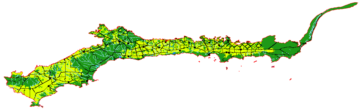
| Description | This is a map showing internal detail of the Interim Biogeographic Regionalisation of Australia (IBRA) Esperance Plains region. Areas that are predominantly given over to agriculture are shown in yellow; those that are still native vegetation are green; barren areas are light brown. Roads, railway lines, towns, watercourses and lakes are also shown. | ||||||||
| Date | |||||||||
| Source | It was created by the uploader. | ||||||||
| Author | Hesperian | ||||||||
| Permission (Reusing this file) |
I, the copyright holder of this work, hereby publish it under the following licenses:
This file is licensed under the Creative Commons Attribution-Share Alike 2.5 Generic, 2.0 Generic and 1.0 Generic license.
You may select the license of your choice. |

File history
Click on a date/time to view the file as it appeared at that time.
| Date/Time | Thumbnail | Dimensions | User | Comment | |
|---|---|---|---|---|---|
| current | 00:20, 14 February 2007 | 1,262 × 381 (56 KB) | Hesperian (talk | contribs) | ocean looked awful | |
| 04:26, 12 February 2007 | 1,262 × 381 (59 KB) | Hesperian (talk | contribs) | {{Information |Description=This is a map showing internal detail of the Interim Biogeographic Regionalisation of Australia (IBRA) '''Esperance Plains''' region. Areas that are predominantly given over to agriculture are shown in yellow; those that are sti |
You cannot overwrite this file.
File usage on Commons
The following page uses this file:
File usage on other wikis
The following other wikis use this file:
- Usage on en.wikipedia.org
- Usage on es.wikipedia.org