File:IAN 0287.jpg
Jump to navigation
Jump to search

Size of this preview: 800 × 491 pixels. Other resolutions: 320 × 196 pixels | 640 × 393 pixels | 1,024 × 629 pixels | 1,280 × 786 pixels | 2,560 × 1,572 pixels | 4,078 × 2,504 pixels.
Original file (4,078 × 2,504 pixels, file size: 5.02 MB, MIME type: image/jpeg)
Captions
Captions
Add a one-line explanation of what this file represents
Summary
[edit]
| Title |
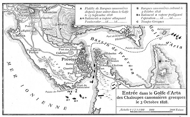
Français : Entrée dans le Golfe d' Arta des Chaloupes canonnieres grecques le 3 Octobre 1828 / The forcing of the straits of Prevesa by the Greek flotilla. |
|||||||||||||||||||||||
| Permission (Reusing this file) |
This file is licensed under the Creative Commons Attribution 4.0 International license.
| |||||||||||||||||||||||
| Attribution (required by the license) | ||||||||||||||||||||||||
| Geotemporal data | ||||||||||||||||||||||||
| Map type | map | |||||||||||||||||||||||
| Spatial reference system | Mercator | |||||||||||||||||||||||
| Heading |
 |
|||||||||||||||||||||||
| Georeferencing | If inappropriate please set warp_status = skip to hide. | |||||||||||||||||||||||
| Bibliographic data | ||||||||||||||||||||||||
| Part of the series |
English: Actia Nicopolis Foundation, Preveza, Greece. Nikos D. Karabelas map collection. Ελληνικά: Ίδρυμα Ακτία Νικόπολις, Πρέβεζα. Συλλογή χαρτών Νίκου Δ. Καράμπελα. |
|||||||||||||||||||||||
| Map sheet | IAN 0287 | |||||||||||||||||||||||
| Archival data | ||||||||||||||||||||||||
| Collection |
|
|||||||||||||||||||||||
| Accession number |
IAN_0287 |
|||||||||||||||||||||||
| Medium |
English: Lithography. Ελληνικά: Λιθογραφία. |
|||||||||||||||||||||||
File history
Click on a date/time to view the file as it appeared at that time.
| Date/Time | Thumbnail | Dimensions | User | Comment | |
|---|---|---|---|---|---|
| current | 12:05, 11 August 2021 | | 4,078 × 2,504 (5.02 MB) | Actia Nicopolis (talk | contribs) | {{Information |Description=== {{int:filedesc}} == {{Map | title = {{fr|1='''Entrée dans le Golfe d' Arta des Chaloupes canonnieres grecques le 3 Octobre 1828 / The forcing of the straits of Prevesa by the Greek flotilla'''.}} | wikidata title = | description = | legend = | author = | imgen = | date = | source = | permission = {{Template:Cc-by-4.0}} | map date = | location = | wikidata location = | projection = Mercator | scale = | heading = 360 | latitude = | long... |
You cannot overwrite this file.
File usage on Commons
There are no pages that use this file.