File:Hypsometric curve of Switzerland.svg

Original file (SVG file, nominally 1,054 × 694 pixels, file size: 34 KB)
Captions
Captions
Summary
[edit]
| Description |
Polski: pl:Krzywa hipsograficzna Szwajcarii
Dane uzyskane z GTOPO30 za pomocą SAGA we wtyczce SEXTANTE do QGIS. 1/4 powierzchni Szwajcarii do 585 m n.p.m. 1/3 do 702 m n.p.m. Mediana - 1074 m n.p.m. 2/3 do 1627 m n.p.m. 3/4 do 1931 m n.p.m. 90 % do 2497 m n.p.m. 95 % do 2738 m n.p.m. 97,5 % do 2938 m n.p.m. 99 % do 3216 m n.p.m. 99,5 % do 3407 m n.p.m. 99,75 % do 3541 m n.p.m. 99,9 % do 3718 m n.p.m.
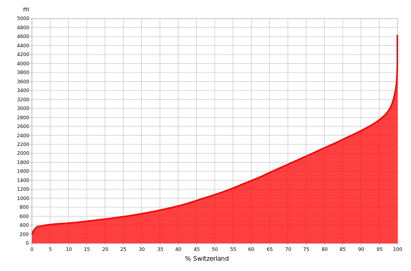
English: en:Hypsometric curve of Switzerland.
Data obtained from en:GTOPO30 by SAGA in SEXTANTE plugin to QGIS. 1/4 area of Switzerland up to 585 m AMSL 1/3 up to 702 m AMSL Median - 1074 m AMSL 2/3 up to 1627 m AMSL ¾ up to 1931 m AMSL 90 % up to 2497 m AMSL 95 % up to 2738 m AMSL 97.5 % up to 2938 m AMSL 99 % up to 3216 m AMSL 99.5 % up to 3407 m AMSL 99.75 % up to 3541 m AMSL 99,9 % up to 3718 m AMSL |
| Date | |
| Source | Own work |
| Author | PawełS |
Licensing
[edit]
- You are free:
- to share – to copy, distribute and transmit the work
- to remix – to adapt the work
- Under the following conditions:
- attribution – You must give appropriate credit, provide a link to the license, and indicate if changes were made. You may do so in any reasonable manner, but not in any way that suggests the licensor endorses you or your use.
- share alike – If you remix, transform, or build upon the material, you must distribute your contributions under the same or compatible license as the original.
File history
Click on a date/time to view the file as it appeared at that time.
| Date/Time | Thumbnail | Dimensions | User | Comment | |
|---|---|---|---|---|---|
| current | 18:01, 24 April 2013 | | 1,054 × 694 (34 KB) | PawełS (talk | contribs) | -border |
| 17:59, 24 April 2013 |  | 1,054 × 694 (34 KB) | PawełS (talk | contribs) | -transparency III | |
| 17:56, 24 April 2013 |  | 1,054 × 694 (34 KB) | PawełS (talk | contribs) | -transparency II | |
| 17:46, 24 April 2013 |  | 1,054 × 694 (34 KB) | PawełS (talk | contribs) | -transparency | |
| 17:26, 24 April 2013 |  | 1,024 × 684 (34 KB) | PawełS (talk | contribs) | crop | |
| 17:19, 24 April 2013 |  | 1,052 × 744 (34 KB) | PawełS (talk | contribs) | =={{int:filedesc}}== {{Information |description={{pl|1=Dane uzyskane z GTOPO30 za pomocą SAGA we wtyczce SEXTANTE do QGIS. ¼ powierzchni Szwajcarii do 585 m n.p.m. ⅓ do 702 m n.p.m. Mediana - 1074 m n.p.m. ⅔ do 1627 m n.p.m. ¾ do 1931 m n.p.... |
You cannot overwrite this file.
File usage on Commons
There are no pages that use this file.