File:Hurricane Matthew (MODIS 2016-10-08).jpg
Original file (7,457 × 5,809 pixels, file size: 4.78 MB, MIME type: image/jpeg)
Captions
Captions
Summary
[edit].jpg&action=edit§ion=1)
| Description |
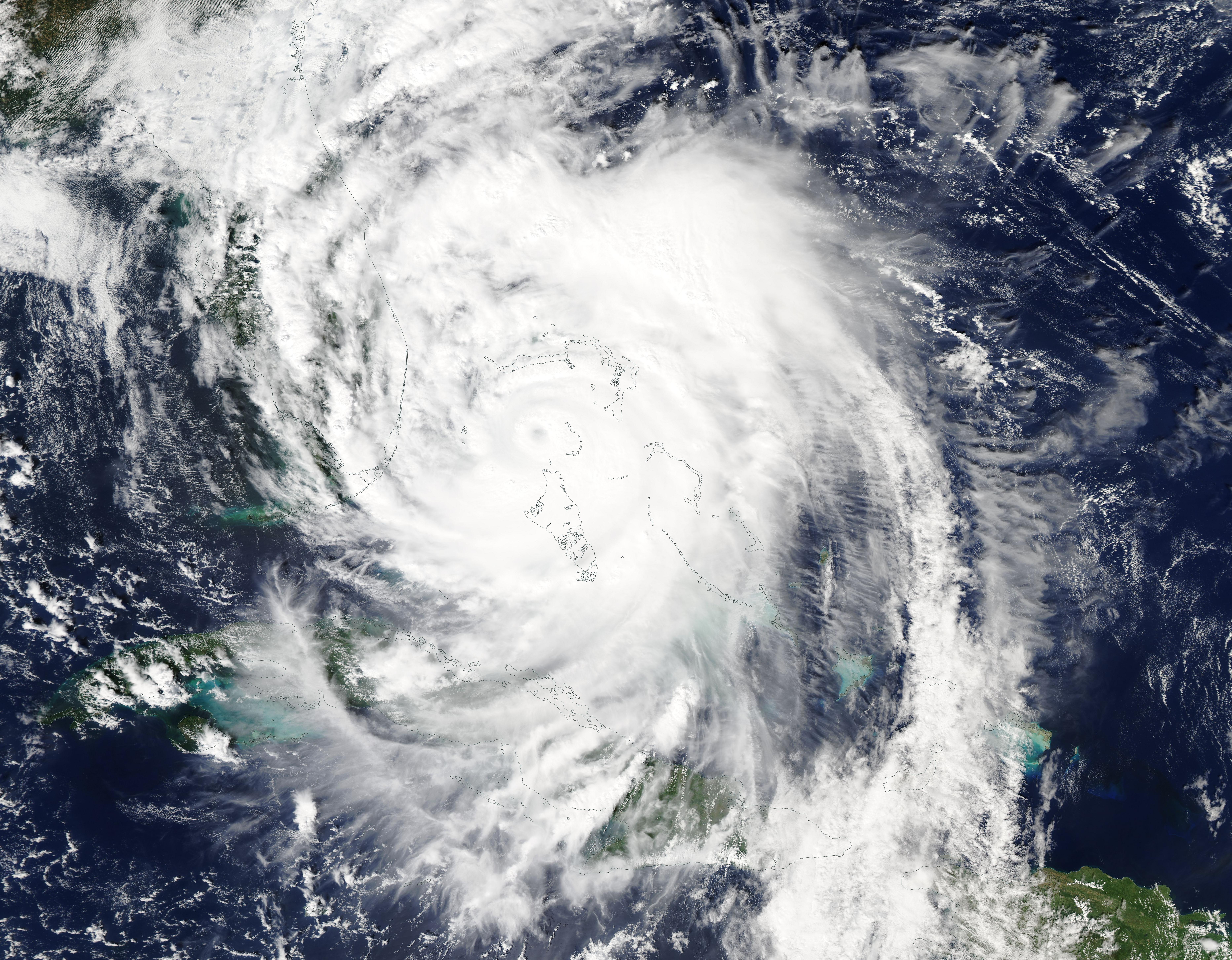
English: On October 6, 2016, satellite imagery showed Hurricane Matthew's clouds already streaming over Florida as it regained Category 4 status in the Atlantic Ocean.
The Moderate Resolution Imaging Spectroradiometer (MODIS) aboard NASA’s Terra satellite captured this true-color image of the powerful storm on October 6. The image shows large Hurricane Matthew's clouds stretching from eastern Cuba and Hispaniola, over the Bahamas and extending to Florida. At 11 a.m. EDT (1500 UTC) on October 6, the eye of Hurricane Matthew was located near 25.1 degrees north latitude and 77.8 degrees west longitude. That's about 25 miles (40 km) west-northwest of Nassau, Bahamas and 180 miles (290 km) southeast of West Palm Beach, Florida. Matthew carried maximum sustained winds near 140 mph (220 km/h) with higher gusts, making it a Category 4 storm on the Saffir-Simpson Hurricane Wind Scale. The intense and deadly Hurricane Matthew began as a tropical wave off the western coast of Africa on September 22. The National Hurricane Center (NHC) named the system Tropical Storm Matthew on September 28 as it spun in the Lesser Antilles. Matthew strengthened to a powerful Category 4 hurricane on September 30, carrying winds of 140 mph (220 km/h) as it headed towards Jamaica. A few hours later the rapidly intensifying storm reached Category 5 status, with winds of 160 mph (260 km/h). It weakened slightly, returning to a Category 4 storm early on October 1. Hurricane Matthew struck the Tiburon Peninsula of Haiti on October 4 as a Category 4 storm – the first Category 4 hurricane landfall in Haiti since Cleo in 1964. It made a second landfall near Juaco, Cuba in the evening of October 4. A third landfall was reported near Freeport, Bahamas on October 6 at a weakened – but still devastating – Category 3 storm with maximum sustained winds near 115 mph (185 km/h). Matthew then began to intensify as it headed towards the coast of Florida. The storm has pounded the coast of Florida for two days, without making landfall. The eyewall, however, has been as close as 10 miles to the coast, according to the Weather Channel. As of 8 p.m. on October 7, the NHC reported that Matthew was located about 55 mi (90 km) east-northeast of Jacksonville Beach, Florida and about 105 mi (170 km) south-southeast of Savannah, Georgia. The storm had weakened, carrying winds of 110 mph (175 km/h), and was now a strong Category 2 storm. The NHC expects Matthew to continue to hug the coastline as it moves northeastward off of North Carolina, then it may begin to circle southeastward as it continues to weaken. Hurricane Matthew has created a wide swath of devastation, particularly in the Caribbean. Haiti has reported over 800 death, along with widespread destruction of property – and the assessment of damage has just begun in many localities. |
||
| Date | Taken on 6 October 2016 | ||
| Source |
Hurricane Matthew (direct link)
|
||
| Author | Jeff Schmaltz, MODIS Land Rapid Response Team, NASA GSFC |
| This media is a product of the Terra mission Credit and attribution belongs to the mission team, if not already specified in the "author" row |
Licensing
[edit].jpg&action=edit§ion=2)
| This file is in the public domain in the United States because it was solely created by NASA. NASA copyright policy states that "NASA material is not protected by copyright unless noted". (See Template:PD-USGov, NASA copyright policy page or JPL Image Use Policy.) | ||
 |
Warnings:
|
File history
Click on a date/time to view the file as it appeared at that time.
| Date/Time | Thumbnail | Dimensions | User | Comment | |
|---|---|---|---|---|---|
| current | 19:17, 15 February 2024 | | 7,457 × 5,809 (4.78 MB) | OptimusPrimeBot (talk | contribs) | #Spacemedia - Upload of http://modis.gsfc.nasa.gov/gallery/images/image10082016_250m.jpg via Commons:Spacemedia |
You cannot overwrite this file.
File usage on Commons
There are no pages that use this file.
.jpg&oldid=868182805)