File:Hurricane Ivan, Natural Hazards DVIDS726877.jpg
Jump to navigation
Jump to search

Size of this preview: 352 × 599 pixels. Other resolutions: 141 × 240 pixels | 282 × 480 pixels | 451 × 768 pixels | 601 × 1,024 pixels | 1,203 × 2,048 pixels | 2,711 × 4,616 pixels.
Original file (2,711 × 4,616 pixels, file size: 4 MB, MIME type: image/jpeg)
Captions
Captions
Add a one-line explanation of what this file represents
Summary
[edit]
| Description |
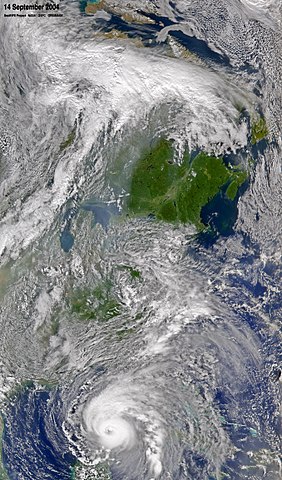
English: The SeaWiFS sensor flying aboard the OrbView-2 satellite captured this true-color image of Hurricane Ivan on September 14, 2004 at 18:00 UTC (2:00 PM EDT). This large view of the eastern half of the country shows a cold front northwest of Lake Michigan. The southeast progression of this front will more than likely steer Ivan up and along the Appalachian Mountains after landfall. Provided by the SeaWiFS Project, NASA/Goddard Space Flight Center, and ORBIMAGE NASA Identifier: Sea2004258180040HurricaneIvan
|
| Date | |
| Source | https://www.dvidshub.net/image/726877/hurricane-ivan-natural-hazards |
| Author | Glenn Research Center |
| Location | WASHINGTON, DC, US |
| Posted | 17 October 2012, 13:33 |
| DVIDS ID | 726877 |
| Archive link | archive copy at the Wayback Machine |
Licensing
[edit]
This image is a work of a U.S. military or Department of Defense employee, taken or made as part of that person's official duties. As a work of the U.S. federal government, the image is in the public domain in the United States.
|
 |
File history
Click on a date/time to view the file as it appeared at that time.
| Date/Time | Thumbnail | Dimensions | User | Comment | |
|---|---|---|---|---|---|
| current | 21:59, 10 March 2017 | | 2,711 × 4,616 (4 MB) | Fæ (talk | contribs) | DVIDS 11 megapixel image from https://www.dvidshub.net/image/726877/hurricane-ivan-natural-hazards. nasa; nasanaturalhazards. Part of User:Fæ/Project list/DoD |
You cannot overwrite this file.
File usage on Commons
There are no pages that use this file.