File:Hurricane Fred Lashes the Cape Verde Islands (21049433881).png

Original file (2,048 × 1,152 pixels, file size: 3.11 MB, MIME type: image/png)
Captions
Captions
Summary
[edit].png&action=edit§ion=1)
| Description |
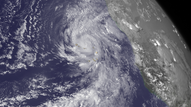
Hurricane Fred is bringing very heavy rains to the Cape Verde Islands. From the National Hurricane Center's Hurricane Fred Forecast Discussion: "According to the official Atlantic tropical cyclone record, which begins in 1851, Fred is the first hurricane to pass through the Cape Verde Islands since 1892. We caution, however, that the database is less reliable prior to the satellite era (mid 1960s onward)." This image was taken by GOES East on August 31, 2015. Credit: NASA/NOAA via <a href="www.nnvl.noaa.gov/" rel="nofollow"> NOAA Environmental Visualization Laboratory</a> NASA Goddard Space Flight Center enables NASA’s mission through four scientific endeavors: Earth Science, Heliophysics, Solar System Exploration, and Astrophysics. Goddard plays a leading role in NASA’s accomplishments by contributing compelling scientific knowledge to advance the Agency’s mission. Follow us on Twitter Like us on Facebook Find us on <a href="http://instagrid.me/nasagoddard/?vm=grid" rel="nofollow">Instagram</a> <a href="http://goes.gsfc.nasa.gov/" rel="nofollow">Credit: NOAA/NASA GOES Project</a> |
| Date | |
| Source | Hurricane Fred Lashes the Cape Verde Islands |
| Author | NASA Goddard Space Flight Center from Greenbelt, MD, USA |
Licensing
[edit].png&action=edit§ion=2)
- You are free:
- to share – to copy, distribute and transmit the work
- to remix – to adapt the work
- Under the following conditions:
- attribution – You must give appropriate credit, provide a link to the license, and indicate if changes were made. You may do so in any reasonable manner, but not in any way that suggests the licensor endorses you or your use.
| This image was originally posted to Flickr by NASA Goddard Photo and Video at https://flickr.com/photos/24662369@N07/21049433881 (archive). It was reviewed on 12 May 2018 by FlickreviewR 2 and was confirmed to be licensed under the terms of the cc-by-2.0. |
| This file is in the public domain in the United States because it was solely created by NASA. NASA copyright policy states that "NASA material is not protected by copyright unless noted". (See Template:PD-USGov, NASA copyright policy page or JPL Image Use Policy.) | ||
 |
Warnings:
|
File history
Click on a date/time to view the file as it appeared at that time.
| Date/Time | Thumbnail | Dimensions | User | Comment | |
|---|---|---|---|---|---|
| current | 01:36, 12 May 2018 | | 2,048 × 1,152 (3.11 MB) | OceanAtoll (talk | contribs) | Transferred from Flickr via #flickr2commons |
You cannot overwrite this file.
File usage on Commons
There are no pages that use this file.
.png&oldid=876035239)